Latitude: 53.1876 / 53°11'15"N
Longitude: -2.8958 / 2°53'44"W
OS Eastings: 340237
OS Northings: 365984
OS Grid: SJ402659
Mapcode National: GBR 79.35E4
Mapcode Global: WH88F.H48N
Plus Code: 9C5V54Q3+2M
Entry Name: Number 1 to 6 Blackfriars Court (Part) and Garden Wall
Listing Date: 20 October 1970
Last Amended: 6 August 1998
Grade: II
Source: Historic England
Source ID: 1376045
English Heritage Legacy ID: 470031
ID on this website: 101376045
Location: Chester, Cheshire West and Chester, Cheshire, CH1
County: Cheshire West and Chester
Electoral Ward/Division: Chester City
Parish: Non Civil Parish
Built-Up Area: Chester
Traditional County: Cheshire
Lieutenancy Area (Ceremonial County): Cheshire
Church of England Parish: Chester St John the Baptist
Church of England Diocese: Chester
Tagged with: House Building Apartment building
SJ4065NW
595-1/5/28
20/10/70
CHESTER CITY (IM)
BLACK FRIARS
(South side)
Nos.1-6 (consec) Blackfriars Court (part) and garden wall
(Formerly Listed as: BLACKFRIARS No.24 (including No.24A) and Nos.28 and 30)
II
GV
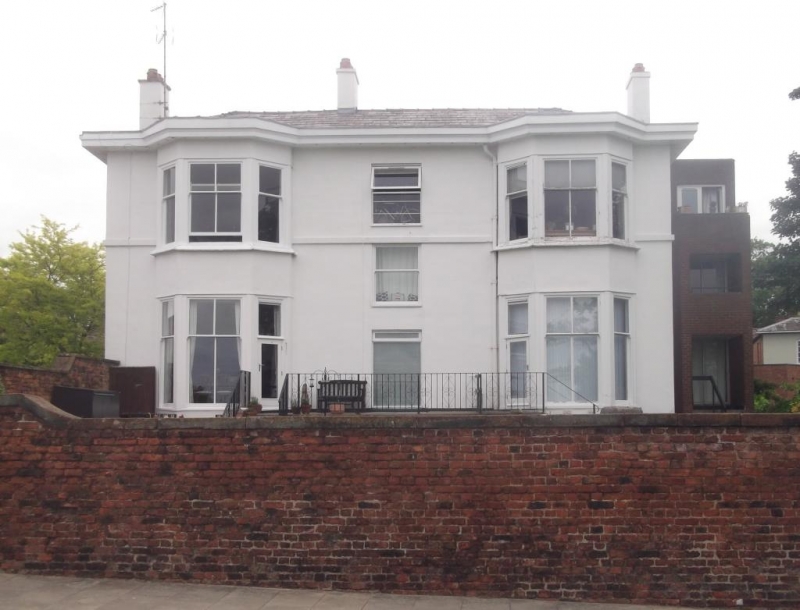
House. c1855. Converted to flats late C20 with some
alterations to the front and built against to rear. Lined
render on brick; hipped grey slate roof.
2 storeys with symmetrical Italianate double-front to west,
formerly the entrance front to Nun's Road. Former central
doorway glazed, with overlight and landing window above
modified; canted 2-storey bay window to each side has nearly
flush horned sashes of 4 panes to front and of 2 panes to each
canted face; band above second storey sill level; boxed
projecting eaves; rendered chimneys, one on ridge and one set
flush at each side.
INTERIOR not inspected.
SUBSIDIARY FEATURES: the English bond brown brick garden wall
to Nun's Road, the south side of the garden and abutting the
house is stone-capped; the wall, which is of sandstone in the
lower courses facing Black Friars, north, is probably older
than the house.
The building is prominently placed above the City Wall, as
seen across the Roodee. The C20 extensions are not of special
interest.
Listing NGR: SJ 40237 65984
External links are from the relevant listing authority and, where applicable, Wikidata. Wikidata IDs may be related buildings as well as this specific building. If you want to add or update a link, you will need to do so by editing the Wikidata entry.


Other nearby listed buildings