Latitude: 50.3624 / 50°21'44"N
Longitude: -4.1648 / 4°9'53"W
OS Eastings: 246122
OS Northings: 53626
OS Grid: SX461536
Mapcode National: GBR R6N.1K
Mapcode Global: FRA 2852.M9N
Plus Code: 9C2Q9R6P+X3
Entry Name: Dock Basin Walls and 6 Associated Bollards, Royal William Victualling Yard
Listing Date: 13 August 1999
Grade: I
Source: Historic England
Source ID: 1378529
English Heritage Legacy ID: 476479
ID on this website: 101378529
Location: Stonehouse, Plymouth, Devon, PL1
County: City of Plymouth
Electoral Ward/Division: St Peter and the Waterfront
Parish: Non Civil Parish
Built-Up Area: Plymouth
Traditional County: Devon
Lieutenancy Area (Ceremonial County): Devon
Tagged with: Architectural structure
SX 4653 NW
740-1/65/732
PLYMOUTH
CREMYLL STREET, Stonehouse
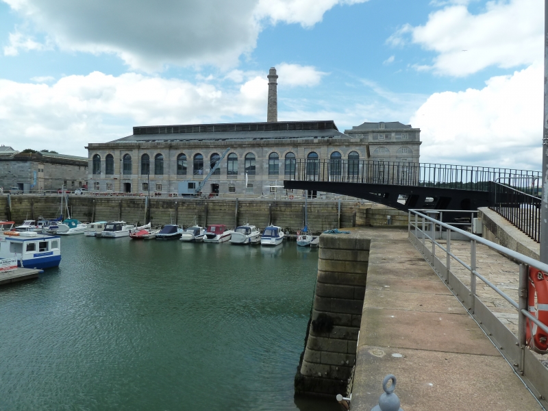
Dock basin walls and 6 associated bollards, Royal William Victualling Yard
GV I
Basin walls and bollards. c1826-32, by Sir J Rennie Jnr, for the Victualling Board. Granite ashlar and cast-iron.
PLAN: square basin with curved NW entrance. Banded rustication to dock sides and entrance, with finely detailed flights of steps either side of the opening.
SUBSIDIARY FEATURES: six square-section cast-iron bollards with concave sides with timber strips, and round top inscribed "FLETCHER AND YOUNG/SOUTHAMPTON/1830", to each corner of the basin and either side of the Swing Bridge (qv).
HISTORY: the Basin was intended to improve access to the Yard for incoming ships, especially during bad weather, and to reduce pilferage. There were formerly cranes along each side. With the Quay Walls each side (qv) it forms the focus, flanked by the Mill and the Brewery and with Melville behind ( qv), of the principal view of the Yard. The Yard is one of the most remarkable and complete early C19 industrial complexes in the country, and a unique English example of Neo-Classical planning of a state manufacturing site.
(Sources: Keystone Historic Buildings Consultants: The Royal William Victualling Yard, Stonehouse: 1994: 50; The Mariner's Mirror: Coad J: Historic Architecture of HM Naval Base Devonport 1689-1850: London: 1983: 382-390; Coad J: The Royal Dockyards 1690-1850: Aldershot: 1989: 282-290).
Listing NGR: SX4612253626
External links are from the relevant listing authority and, where applicable, Wikidata. Wikidata IDs may be related buildings as well as this specific building. If you want to add or update a link, you will need to do so by editing the Wikidata entry.


Other nearby listed buildings