Approximate Location Map
Large Map »
Latitude: 51.5601 / 51°33'36"N
Longitude: -0.1786 / 0°10'42"W
OS Eastings: 526357
OS Northings: 186150
OS Grid: TQ263861
Mapcode National: GBR D0.FMR
Mapcode Global: VHGQR.V1FW
Plus Code: 9C3XHR6C+2H
Entry Name: Boundary Wall, Piers and Southern Gate
Listing Date: 11 January 1999
Grade: II
Source: Historic England
Source ID: 1378852
English Heritage Legacy ID: 478210
ID on this website: 101378852
Location: Vale of Health, Camden, London, NW3
County: London
District: Camden
Electoral Ward/Division: Hampstead Town
Parish: Non Civil Parish
Built-Up Area: Camden
Traditional County: Middlesex
Lieutenancy Area (Ceremonial County): Greater London
Church of England Parish: Christ Church Hampstead
Church of England Diocese: London
Tagged with: Wall
CAMDEN
TQ2686SW HEATH STREET
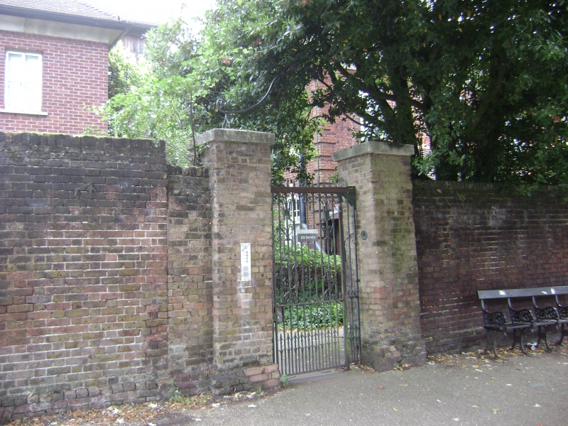
798-1/16/1767 (East side)
Boundary wall, piers and southern
gate
GV II
Boundary wall. Early C18 and later. Pink-red bricks, with
stone copings to gate piers, in Flemish bond. The wall runs
from the northernmost pair of gate piers 20m north of the most
northerly of two K6 telephone kiosks (qv) 60m long and about 2
or more metres in height. Later C19 phase of pink-yellow brick
between middle and southern gate piers; adjoining 70m length
of yellow brick in Dutch bond beginning at second of 2
distinctive insets. 3 gate piers are set into the wall, the 2
most southerly with wrought-iron overthrows. Spiked iron
bracket in bend of first inset. C18 wrought-iron gate set
within southernmost gate piers. Renewed coping along entire
length.
HISTORICAL NOTE: this wall was formerly attached to the Upper
Flask Tavern, summer meeting place of the Kit-Kat Club, and
referred to in Richardson's 'Clarissa' (1748). The tavern was
converted to domestic use in the later C18 and renamed Upper
Heath. The house was demolished in 1922 when Queen Mary's
Maternity Home was built.
The wall is depicted in several topographical prints of the
former Upper Flask: they show that the middle section, the C19
section of pink-yellow bricks, replaced a dwarf wall that
stood in front of the west side of Upper Heath which enabled
the view towards Harrow to be enjoyed. Anna Maxwell's
'Hampstead', c1910, p.45 declared that 'no remnant of old
Hampstead is more arresting than the sight of the strong, high
garden wall at the summit of Heath Street, with its ancient
towering trees within.'
(Maxwell A: Hampstead: London: 1910-: 45; Barratt T: The
Annals of Hampstead: London: 1912-: 200).
Listing NGR: TQ2635786152
External links are from the relevant listing authority and, where applicable, Wikidata. Wikidata IDs may be related buildings as well as this specific building. If you want to add or update a link, you will need to do so by editing the Wikidata entry.


Other nearby listed buildings
