Approximate Location Map
Large Map »
Latitude: 53.5636 / 53°33'48"N
Longitude: -0.0885 / 0°5'18"W
OS Eastings: 526695
OS Northings: 409142
OS Grid: TA266091
Mapcode National: GBR WWT7.M8
Mapcode Global: WHHHS.MP1F
Plus Code: 9C5XHW76+CH
Entry Name: The White Hart Public House
Listing Date: 31 October 1974
Grade: II
Source: Historic England
Source ID: 1379371
English Heritage Legacy ID: 478750
ID on this website: 101379371
Location: Grimsby, North East Lincolnshire, DN31
County: North East Lincolnshire
Electoral Ward/Division: West Marsh
Parish: Non Civil Parish
Built-Up Area: Grimsby
Traditional County: Lincolnshire
Lieutenancy Area (Ceremonial County): Lincolnshire
Church of England Parish: Great Grimsby St Mary and St James
Church of England Diocese: Lincoln
Tagged with: Pub
GRIMSBY
TA2609SE BETHLEHEM STREET
699-1/21/12 (South side)
31/10/74 Nos.1 AND 3
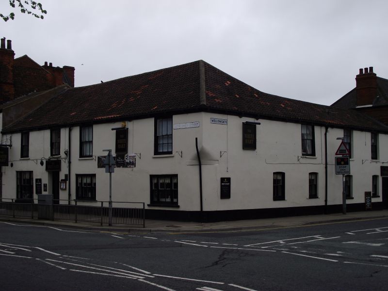
The White Hart Public House
II
Includes: The White Hart Public House WELLOWGATE.
2 houses, now public house. Mid C18 with later C19
alterations. Brick, rendered. Pantile roof. L-shaped on plan:
occupies street corner site.
EXTERIOR: 2 storeys; irregular fenestration: 4 first-floor
windows to Bethlehem Street front, 3 to Wellowgate front.
Plinth. Angled corner to right, corbelled-out above. Recessed
door to left of centre beneath 3-pane overlight. To its left,
a tripartite sash with glazing-bars. To right, a pair of
tripartite plate-glass sashes, each with 2/2 panes to their
central sash. First floor has a pair of 2/6 sashes to left in
flush wood architraves, and a pair of slightly larger similar
sashes to right with vertical glazing bars, apart from the
lower right sash with 6 panes. All windows with stone sills.
Modillioned wooden gutter. Roof hipped to right.
Wellowgate front has later 2-storey section to right. 2
ground-floor 2/2 sashes to left, 2 sashes set slightly lower
to right, all beneath segmental arches. Door to far right.
First floor has single large 2/2 sash to left, pair of 6/6
sashes to right.
INTERIOR: refitted in late C20.
(Grimsby - Action for Conservation: Grimsby Borough Planning
Department: List of buildings of local architectural or
historical interest: Grimsby Borough Council: 1972-: NO.24;
Grimsby Planning Department: Central Conservation Area:
Grimsby Borough Council: 1990-: MAP; Grimsby Planning
Department: Top Town Trail: Grimsby: 1989-: NO.4).
Listing NGR: TA2669109143
External links are from the relevant listing authority and, where applicable, Wikidata. Wikidata IDs may be related buildings as well as this specific building. If you want to add or update a link, you will need to do so by editing the Wikidata entry.


Other nearby listed buildings
