Latitude: 53.5378 / 53°32'16"N
Longitude: -0.092 / 0°5'31"W
OS Eastings: 526546
OS Northings: 406267
OS Grid: TA265062
Mapcode National: GBR WWSJ.WJ
Mapcode Global: WHHHZ.KBFP
Plus Code: 9C5XGWQ5+46
Entry Name: Island House
Listing Date: 14 July 1970
Last Amended: 30 June 1999
Grade: II
Source: Historic England
Source ID: 1379865
English Heritage Legacy ID: 479300
ID on this website: 101379865
Location: Scartho, North East Lincolnshire, DN33
County: North East Lincolnshire
Electoral Ward/Division: Scartho
Parish: Non Civil Parish
Built-Up Area: Grimsby
Traditional County: Lincolnshire
Lieutenancy Area (Ceremonial County): Lincolnshire
Church of England Parish: Scartho St Giles with St Matthew
Church of England Diocese: Lincoln
Tagged with: House
GRIMSBY
TA2606SE PINFOLD LANE, Scartho
699-1/40/117 (East side)
14/07/70 No.1
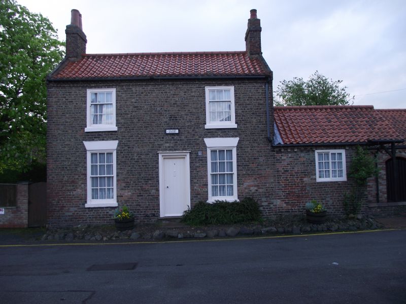
Island House
(Formerly Listed as:
PINFOLD LANE, Scartho
(East side)
No.1)
II
House. Late C18 with late C20 additions to rear. Brown brick
in English garden wall bond. Pantile roof. 2 rooms to front
with direct entry to right-hand room; single-room extension to
right.
EXTERIOR: 2 storeys, 2 first-floor windows, with a
single-storey, single-window extension. Board door in
architrave flanked by 6/6 sashes in flush wood architraves
with stone sills and stucco flat arches. C20 3/6 first-floor
sashes. 6/6 horizontal sliding sash to extension. Stepped and
cogged brick eaves cornice to front, dentilled cornice to
rear. Tumbled brick to raised gables bearing wrought-iron
letters W K to left. End stacks.
INTERIOR: not inspected.
(Grimsby - Action for Conservation: Grimsby Borough Planning
Department: List of buildings of local architectural or
historical interest: Grimsby Borough Council: 1972-: NO.60;
Grimsby Planning Department: Scartho Conservation Area:
Grimsby Borough Council: 1972-: NO.60).
Listing NGR: TA2654606267
External links are from the relevant listing authority and, where applicable, Wikidata. Wikidata IDs may be related buildings as well as this specific building. If you want to add or update a link, you will need to do so by editing the Wikidata entry.


Other nearby listed buildings