Approximate Location Map
Large Map »
Latitude: 52.3787 / 52°22'43"N
Longitude: -2.3057 / 2°18'20"W
OS Eastings: 379284
OS Northings: 275668
OS Grid: SO792756
Mapcode National: GBR 0BC.ZV7
Mapcode Global: VH91S.ZGDW
Plus Code: 9C4V9MHV+FP
Entry Name: Churchyard Walls and Lychgate at Church of All Saints
Listing Date: 14 April 2000
Grade: II
Source: Historic England
Source ID: 1380210
English Heritage Legacy ID: 479908
ID on this website: 101380210
Location: All Saints' Church, Wribbenhall, Wyre Forest, Worcestershire, DY12
County: Worcestershire
District: Wyre Forest
Civil Parish: Bewdley
Built-Up Area: Bewdley
Traditional County: Worcestershire
Lieutenancy Area (Ceremonial County): Worcestershire
Church of England Parish: Wribbenhall
Church of England Diocese: Worcester
Tagged with: Churchyard wall
BEWDLEY
S07975 KIDDERMINSTER ROAD
1618/11/10016 Wribbenhall
14-APR-00 Churchyard walls and Lychgate at Churc
h of All Saints
GV II
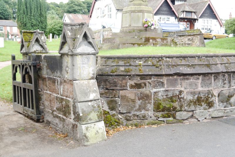
Churchyard walls and lychgate. Circa 1878; possibly by Arthur Blomfield. Sandstone with freestone dressings, timber-framing, cross-gabled shingle roof with lead roll ridges. A low sandstone churchyard boundary wall on the north, west and south sides of the churchyard, with saddle-back coping and weathered raking buttresses; pedestrian gateways, their gate-piers with gableted caps, and an ornate cast-iron lamp standard at the east end of the north wall. Towards the west end of the north side the walls sweep into the lychgate with its low stone lateral plinth walls and a cross-gabled open timber-frame superstructure with curved braces to the tie-beams, cusped panels in the gables, ornate cusped bargeboards and a small cross finial on the ridge.
Listing NGR: SO7928475668
External links are from the relevant listing authority and, where applicable, Wikidata. Wikidata IDs may be related buildings as well as this specific building. If you want to add or update a link, you will need to do so by editing the Wikidata entry.


Other nearby listed buildings
