Latitude: 50.7232 / 50°43'23"N
Longitude: -3.532 / 3°31'55"W
OS Eastings: 291954
OS Northings: 92632
OS Grid: SX919926
Mapcode National: GBR P0.PZKS
Mapcode Global: FRA 37H5.FSB
Plus Code: 9C2RPFF9+75
Entry Name: 199, High Street
Listing Date: 23 June 2000
Grade: II
Source: Historic England
Source ID: 1380822
English Heritage Legacy ID: 481146
ID on this website: 101380822
Location: Exeter, Devon, EX4
County: Devon
District: Exeter
Electoral Ward/Division: St David's
Parish: Non Civil Parish
Built-Up Area: Exeter
Traditional County: Devon
Lieutenancy Area (Ceremonial County): Devon
Church of England Parish: Central Exeter
Church of England Diocese: Exeter
Tagged with: Building
SX 9192 NE HIGH STREET
871/2/10065 (Northwest side)
23-JUN-00 199
II
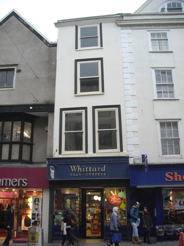
Very narrow town house now with shop at ground floor level. C18 front but suspected to be an earlier build behind. Stuccoed and painted, probably timber-framed. Roof covering not visible due to parapet; concealed rainwater goods.
Plan: Deep rectangular plan.
Exterior: 4 storeys, 1 window wide at second and third floor, 2 windows at first floor. Parapet above deeply projecting cornice. Possibly a jetty at first floor concealed by shop fascia, indicating that the building may be timber framed. Ground floor has C20 shop front with plate glass windows and recessed entrance. Windows above are all boxed sashes with moulded architraves reglazed as 2-pane horned sashes.
INTERIOR: Ground floor front has been gutted for C20 shop use, features of interest may survive elsewhere.
Many of the High Street houses which escaped bomb damage are C17 or earlier in origin.
Listing NGR: SX9195492632
External links are from the relevant listing authority and, where applicable, Wikidata. Wikidata IDs may be related buildings as well as this specific building. If you want to add or update a link, you will need to do so by editing the Wikidata entry.


Other nearby listed buildings