Approximate Location Map
Large Map »
Latitude: 51.5648 / 51°33'53"N
Longitude: -1.8002 / 1°48'0"W
OS Eastings: 413946
OS Northings: 185123
OS Grid: SU139851
Mapcode National: GBR YND.1C
Mapcode Global: VHB3D.RX5S
Plus Code: 9C3WH57X+WW
Entry Name: Brick Boundary Wall to Former GWR Works (North)
Listing Date: 22 August 2000
Grade: II
Source: Historic England
Source ID: 1382136
English Heritage Legacy ID: 482504
ID on this website: 101382136
Location: Even Swindon, Swindon, Wiltshire, SN2
County: Swindon
Electoral Ward/Division: Mannington and Western
Parish: Central Swindon North
Built-Up Area: Swindon
Traditional County: Wiltshire
Lieutenancy Area (Ceremonial County): Wiltshire
Church of England Parish: Swindon St Augustine
Church of England Diocese: Bristol
Tagged with: Wall
SU18NW
1097/1/10019
22-AUG-00
RODBOURNE ROAD
Swindon
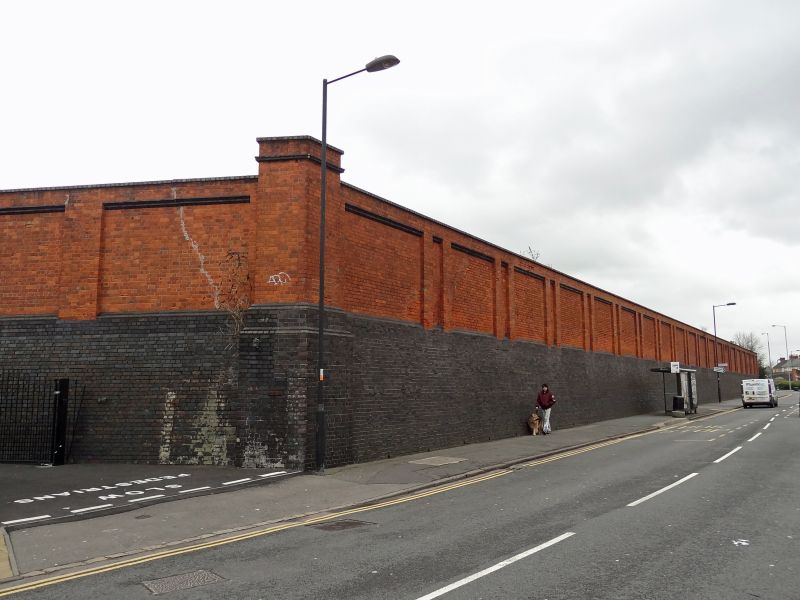
Brick boundary wall to former GWR works (north)
GV
II
Retaining and boundary wall. Constructed between 1870-1880 by the Great Western Railway. Red brick wall with a blue brick plinth, 90m north-south fronting Rodbourne Road and 140m east-west running parallel to the rear of Hawkins Street. Red brick in alternate courses of headers and stretchers buttressed at 5m intervals on the east and south sides. Metal signs with GWR lettering remain attached to parts of the northern length. Blue engineering bricks used in buttresses and angled brick coping. The inside (former GWR Works site) has a ground level some 4m higher than Rodbourne Road and the wall at its base acts as a retaining wall, this is the plinth of blue engineering bricks. Side to Rodbourne Road stands 8m high. Top 4m of red brick with inset panels and blue brick details above a 4m blue brick plinth.
History: Built as part of the northern and western boundary of the GWR Works to the east of Rodbourne Road. The 'Hawksworth Plans' show that this wall was constructed between 1870-1880.
References: J Cattell and K Falconer, The Legacy of a Railway Town, RCHME, HMSO, London
Hawksworth Plans of GWR Works, Records Office, Railtrack plc, Swindon.
Information from Swindon Borough Council Planning
Listing NGR: SU1394685123
External links are from the relevant listing authority and, where applicable, Wikidata. Wikidata IDs may be related buildings as well as this specific building. If you want to add or update a link, you will need to do so by editing the Wikidata entry.


Other nearby listed buildings
