Approximate Location Map
Large Map »
Latitude: 51.2096 / 51°12'34"N
Longitude: -2.6498 / 2°38'59"W
OS Eastings: 354703
OS Northings: 145805
OS Grid: ST547458
Mapcode National: GBR MN.42GL
Mapcode Global: VH89S.1V0K
Plus Code: 9C3V6952+V3
Entry Name: 38, Chamberlain Street
Listing Date: 12 November 1953
Grade: II
Source: Historic England
Source ID: 1382939
English Heritage Legacy ID: 483342
ID on this website: 101382939
Location: Wells, Somerset, BA5
County: Somerset
District: Mendip
Civil Parish: Wells
Built-Up Area: Wells
Traditional County: Somerset
Lieutenancy Area (Ceremonial County): Somerset
Tagged with: Building
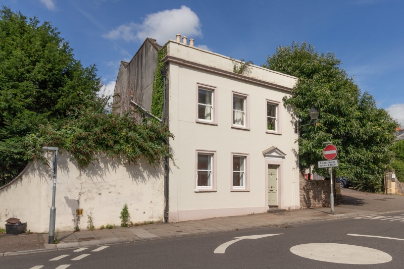
WELLS
ST5445 CHAMBERLAIN STREET
662-1/7/69 (North side)
12/11/53 No.38
GV II
Detached house. Early/mid C19. Rendered and colourwashed,
Welsh slate covered double roof between coped gables, brick
chimney stack. Double-depth plan.
EXTERIOR: 2 storeys, 3 bays. Plinth, end pilasters, cornice,
plain parapet. Plain sash windows in moulded architraves.
Entrance in bay 3, with 6-panel door set in plain architrave
with pediment hood.
INTERIOR: not inspected.
Listing NGR: ST5470345805
External links are from the relevant listing authority and, where applicable, Wikidata. Wikidata IDs may be related buildings as well as this specific building. If you want to add or update a link, you will need to do so by editing the Wikidata entry.


Other nearby listed buildings
