Approximate Location Map
Large Map »
Latitude: 51.2089 / 51°12'32"N
Longitude: -2.6473 / 2°38'50"W
OS Eastings: 354879
OS Northings: 145725
OS Grid: ST548457
Mapcode National: GBR MN.433W
Mapcode Global: VH89S.2WB3
Plus Code: 9C3V6953+H3
Entry Name: Number 28 and Attached Buildings to Rear
Listing Date: 13 September 1972
Grade: II
Source: Historic England
Source ID: 1382968
English Heritage Legacy ID: 483371
ID on this website: 101382968
Location: Wells, Somerset, BA5
County: Somerset
District: Mendip
Town: Mendip
Civil Parish: Wells
Built-Up Area: Wells
Traditional County: Somerset
Lieutenancy Area (Ceremonial County): Somerset
Tagged with: Building
WELLS
ST5445 HIGH STREET
662-1/7/102 (North side)
13/09/72 No.28
and attached buildings to rear
GV II
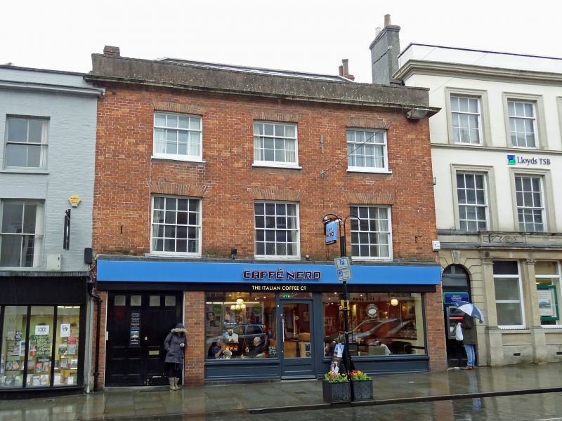
House with shop. Late C18, with an early C17 building to rear.
Red brick with stone dressings and rendered parapet, hipped
Welsh slate roof, brick chimney stacks.
EXTERIOR: 3 storeys, 3 bays. Ground floor has through passage
with early C20 flush panel doors to left, then a later C20
shop front with plain glass doors almost central on bay 2,
under medium depth plain fascia. Upper floors have sash
windows in plain openings with stone sills and flat gauged
brick arches, 16-pane to first floor and 12-pane to second
floor, under cornice and plain parapet. Rear of main building
has a 12-pane horizontal sliding sash to second floor.
INTERIOR: front building, the whole ground floor opened up,
but to first floor there are 4-fielded-panel doors, chamfered
ceiling beams with runout stops, and in SE corner a C18 arched
recess with cupboard under. In the cupboard under the stairs
is a carved corbel stone, possibly a head. On second floor
mostly C19 partitioning. Cellar not seen.
SUBSIDIARY FEATURES: behind is an early C20 extension, then a
crosswing, oversailing the throughway of C19 date, behind
which is a C17 building at right angles to roadline, 2
storeys, with modern roof, but with two ovolo-mould stone
mullioned windows, one 3-light and one 4-light, although
blocked internally the windows retain some old rectangular-
leaded glazing. Attached to north end of this building are the
former stables, possibly C18, with collar-beam roof trusses
and diagonal windbracing, with brick paviour floor, a timber
partition across the partial first floor, and in the west wall
towards the rear traces of a pointed arch doorway now blocked.
Listing NGR: ST5487945725
External links are from the relevant listing authority and, where applicable, Wikidata. Wikidata IDs may be related buildings as well as this specific building. If you want to add or update a link, you will need to do so by editing the Wikidata entry.


Other nearby listed buildings
