Approximate Location Map
Large Map »
Latitude: 51.4969 / 51°29'48"N
Longitude: -0.0805 / 0°4'49"W
OS Eastings: 533338
OS Northings: 179298
OS Grid: TQ333792
Mapcode National: GBR VK.1K
Mapcode Global: VHGR0.KM8V
Plus Code: 9C3XFWW9+QQ
Entry Name: 5, 6 and 7, Grange Walk
Listing Date: 27 September 1972
Grade: II
Source: Historic England
Source ID: 1385569
English Heritage Legacy ID: 470972
ID on this website: 101385569
Location: Bermondsey, Southwark, London, SE1
County: London
District: Southwark
Electoral Ward/Division: Grange
Parish: Non Civil Parish
Built-Up Area: Southwark
Traditional County: Surrey
Lieutenancy Area (Ceremonial County): Greater London
Church of England Parish: Bermondsey St Mary Magdalen, St Olave, St John and St Luke
Church of England Diocese: Southwark
Tagged with: Building
SOUTHWARK
TQ3379 GRANGE WALK
636-1/5/387 (South side)
27/09/72 Nos.5, 6 AND 7
GV II
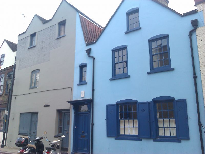
3 houses, incorporating remains of medieval abbey gatehouse.
Late C17, altered. Stuccoed with tiled pitched roofs. Gable
ends to street, 2-span gable to Nos 6 & 7 with mansarded right
side.
No.5: 2 storeys and attic, 2 main bays, with door and narrow
window above to left side. Door has overlight and wooden
architrave with moulded pilasters and flat hood on carved
brackets. Segmental-headed sash windows with glazing bars,
those to ground-floor with shutters.
No.6: 2 storeys and attic, 1 bay, irregular fenestration.
Later doorway. 1st floor blind.
No.7: 2 storeys and attic, 1 bay. Later doorway. Irregular
fenestration.
Within the structure of these houses is part of one side of a
late mediaeval stone gatehouse to Bermondsey Abbey. To left is
chamfered south jamb of gateway with 2 wrought-iron gate
crooks projecting from wall.
INTERIOR: not inspected.
Nos 5-11 (consec) (qqv) form a group.
Listing NGR: TQ3333879298
External links are from the relevant listing authority and, where applicable, Wikidata. Wikidata IDs may be related buildings as well as this specific building. If you want to add or update a link, you will need to do so by editing the Wikidata entry.


Other nearby listed buildings
