Approximate Location Map
Large Map »
Latitude: 51.4718 / 51°28'18"N
Longitude: -0.0709 / 0°4'15"W
OS Eastings: 534079
OS Northings: 176520
OS Grid: TQ340765
Mapcode National: GBR XV.6L
Mapcode Global: VHGR6.Q8CL
Plus Code: 9C3XFWCH+PJ
Entry Name: Post Office Depot
Listing Date: 27 September 1972
Last Amended: 17 September 1998
Grade: II
Source: Historic England
Source ID: 1385607
English Heritage Legacy ID: 471011
ID on this website: 101385607
Location: Peckham, Southwark, London, SE15
County: London
District: Southwark
Electoral Ward/Division: The Lane
Parish: Non Civil Parish
Built-Up Area: Southwark
Traditional County: Surrey
Lieutenancy Area (Ceremonial County): Greater London
Church of England Parish: Peckham All Saints
Church of England Diocese: Southwark
Tagged with: Post office
SOUTHWARK
TQ3476 HIGHSHORE ROAD
636-1/12/432 (North side)
27/09/72 Post Office Depot
(Formerly Listed as:
HIGHSHORE ROAD
(North side)
Friends Meeting House (now Post
Office depot))
GV II
Formerly known as: Peckham Meeting House of the Society of
Friends HIGHSHORE ROAD.
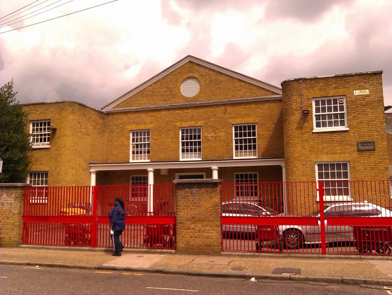
Friends' meeting house, now post office depot. 1826, enlarged
1843. Stock brick with low-pitched, hipped slate roof.
2 storeys, with simple, 3-bay pedimented centre section
flanked by projecting 1 bay wings with curved inner returns.
Timber Tuscan loggia to ground-floor centre section. Double
door with moulded architrave to centre; windows 20-pane sashes
with glazing bars and flat, gauged-brick arches. Louvred
oculus in tympanum.
INTERIOR: not inspected.
The Post Office Depot and Nos 7-11 (odd) (qv) form a group.
Listing NGR: TQ3407976520
External links are from the relevant listing authority and, where applicable, Wikidata. Wikidata IDs may be related buildings as well as this specific building. If you want to add or update a link, you will need to do so by editing the Wikidata entry.


Other nearby listed buildings
