Latitude: 51.4699 / 51°28'11"N
Longitude: -0.071 / 0°4'15"W
OS Eastings: 534078
OS Northings: 176314
OS Grid: TQ340763
Mapcode National: GBR XW.57
Mapcode Global: VHGR6.QB90
Plus Code: 9C3XFW9H+XH
Entry Name: 17 and 18, Holly Grove
Listing Date: 27 September 1972
Last Amended: 17 September 1998
Grade: II
Source: Historic England
Source ID: 1385613
English Heritage Legacy ID: 471017
ID on this website: 101385613
Location: Peckham, Southwark, London, SE15
County: London
District: Southwark
Electoral Ward/Division: The Lane
Parish: Non Civil Parish
Built-Up Area: Southwark
Traditional County: Surrey
Lieutenancy Area (Ceremonial County): Greater London
Church of England Parish: Peckham All Saints
Church of England Diocese: Southwark
Tagged with: Building
SOUTHWARK
TQ3476 HOLLY GROVE
636-1/12/438 (South side)
27/09/72 Nos.17 AND 18
(Formerly Listed as:
HOLLY GROVE
(South side)
Nos.17-20)
GV II
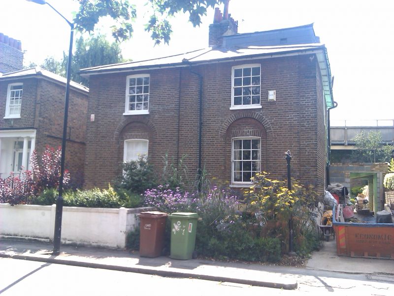
Pair of semi-detached houses, c1816-22. Brick with
low-pitched, hipped slate roof, No.18 with added slate mansard
with dormer.
2 storey and basement (and attic to no.18), 1 main bay each
(No.17 with 1-storey entrance extension to left). No.18 has
steps up to door in return elevation. No.17 has windows
recently replaced. No.18 has sash windows with glazing bars
and cambered, gauged-brick arches in slightly projecting
section, those to ground-floor within round-arched recess.
INTERIOR: not inspected.
Included for group value.
Nos 5-24 (consec) (qqv) form a group.
Listing NGR: TQ3407876314
External links are from the relevant listing authority and, where applicable, Wikidata. Wikidata IDs may be related buildings as well as this specific building. If you want to add or update a link, you will need to do so by editing the Wikidata entry.


Other nearby listed buildings