Approximate Location Map
Large Map »
Latitude: 51.8924 / 51°53'32"N
Longitude: -2.0875 / 2°5'15"W
OS Eastings: 394074
OS Northings: 221539
OS Grid: SO940215
Mapcode National: GBR 2MB.71S
Mapcode Global: VH947.RPSN
Plus Code: 9C3VVWR6+WX
Entry Name: 54 and 56, Andover Road
Listing Date: 14 December 1983
Last Amended: 26 November 1998
Grade: II
Source: Historic England
Source ID: 1386685
English Heritage Legacy ID: 474081
ID on this website: 101386685
Location: Tivoli, Cheltenham, Gloucestershire, GL50
County: Gloucestershire
District: Cheltenham
Town: Cheltenham
Electoral Ward/Division: Park
Parish: Non Civil Parish
Built-Up Area: Cheltenham
Traditional County: Gloucestershire
Lieutenancy Area (Ceremonial County): Gloucestershire
Church of England Parish: Cheltenham St Stephen
Church of England Diocese: Gloucester
Tagged with: Building
CHELTENHAM
SO9421NW ANDOVER ROAD
630-1/17/138 (South side)
14/12/83 Nos.54 AND 56
(Formerly Listed as:
ANDOVER ROAD
Nos.54 AND 56
(Lypiatt Street))
GV II
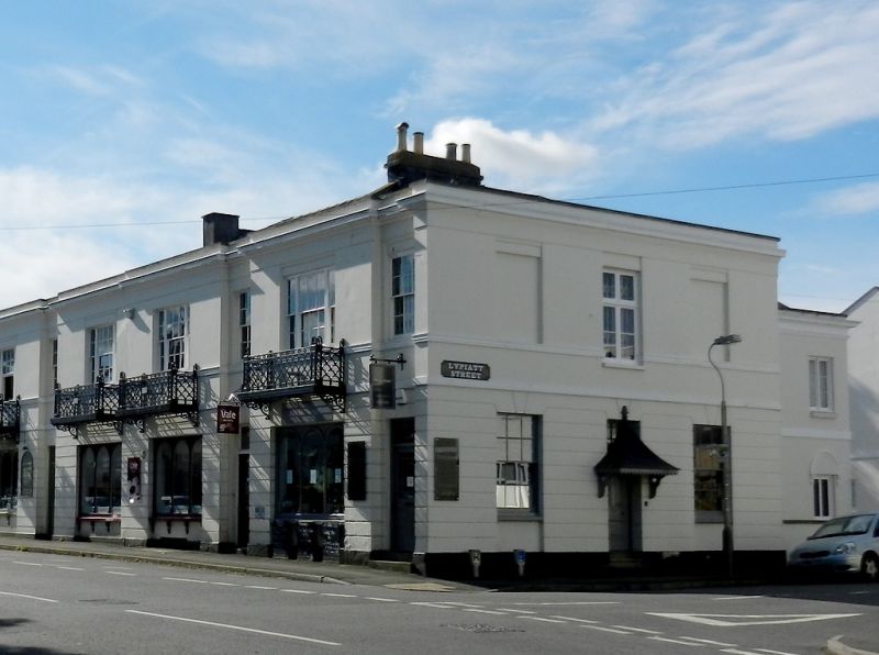
2 terraced houses, now shops. c1840s with later alterations,
including those c1980s to ground-floor shops. Stucco over
brick with slate roof and iron porch.
EXTERIOR: 2 storeys, 2 bays each, a narrower set back bay and
wider one with tripartite window; 6/6 and 6/6 between 2/2
sashes. Ground floor has horizontal rustication; crowning
cornice and blocking course. Left entrances, part-glazed and
panelled doors with margin-lights and lower flush panels.
Renewed shop fronts have shaped mullions and round-arched
panes. Right return: 3 first-floor windows. 6/6 sashes and
blind openings. Central entrance a 3-panel door with raised
and fielded upper panels and lower flush panels, overlight
with margin-lights and tent hood on brackets. Service range to
rear.
INTERIOR: not inspected.
Part of a terrace that is otherwise rebuilt. A similar design
to Nos 32, 34 and 36, 60A and B, 62-70 (even), and 72-80
(even), Andover Road (qqv).
Listing NGR: SO9406821535
External links are from the relevant listing authority and, where applicable, Wikidata. Wikidata IDs may be related buildings as well as this specific building. If you want to add or update a link, you will need to do so by editing the Wikidata entry.


Other nearby listed buildings
