Approximate Location Map
Large Map »
Latitude: 52.112 / 52°6'43"N
Longitude: -2.0757 / 2°4'32"W
OS Eastings: 394911
OS Northings: 245963
OS Grid: SO949459
Mapcode National: GBR 2JM.J0Z
Mapcode Global: VH938.Z50S
Plus Code: 9C4V4W6F+QP
Entry Name: 55, High Street
Listing Date: 31 December 1971
Grade: II
Source: Historic England
Source ID: 1387095
English Heritage Legacy ID: 474511
ID on this website: 101387095
Location: Pershore, Wychavon, Worcestershire, WR10
County: Worcestershire
District: Wychavon
Civil Parish: Pershore
Built-Up Area: Pershore
Traditional County: Worcestershire
Lieutenancy Area (Ceremonial County): Worcestershire
Church of England Parish: Pershore
Church of England Diocese: Worcester
Tagged with: Building
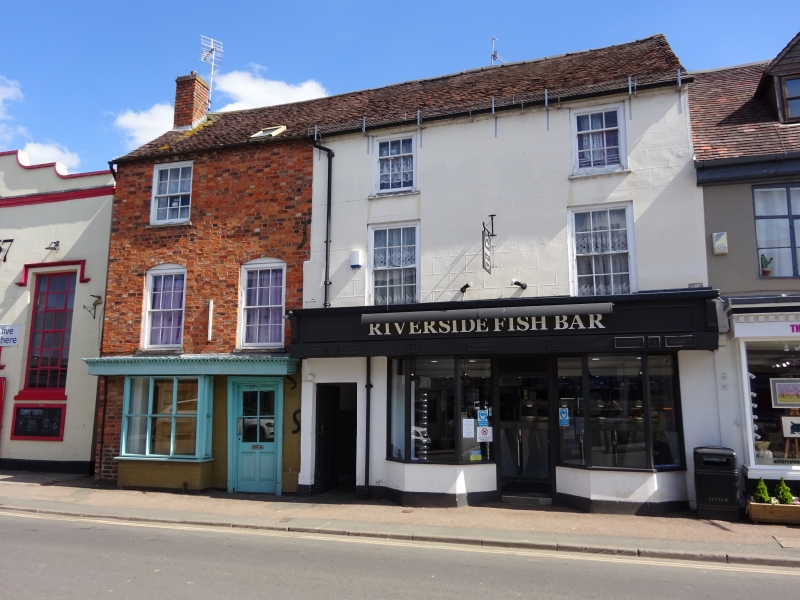
PERSHORE
SO9445 HIGH STREET
648-1/5/145 (East side)
31/12/71 No.55
GV II
House. Second half C18, much altered C20. Mostly red brick in
Flemish bond with part-painted ground floor. Roof of old plain
tiles with brick dentilled eaves, brick end-stack on left, and
C20 roof-light on right.
EXTERIOR: 3 storeys; 2-window range with C20 rear wing. Second
floor has a single 6/6 sash, 1st floor two 6/6 sashes under
segmental brick arches, all with concrete sills. Ground floor:
fascia with leaded dentilled cornice; plate glass bay-window
on left; on right, entrance with architrave and C20
part-glazed C20 door.
INTERIOR: not inspected.
Listing NGR: SO9492145982
External links are from the relevant listing authority and, where applicable, Wikidata. Wikidata IDs may be related buildings as well as this specific building. If you want to add or update a link, you will need to do so by editing the Wikidata entry.


Other nearby listed buildings
