Approximate Location Map
Large Map »
Latitude: 50.9207 / 50°55'14"N
Longitude: -1.3883 / 1°23'17"W
OS Eastings: 443094
OS Northings: 113645
OS Grid: SU430136
Mapcode National: GBR RSV.HH
Mapcode Global: FRA 76ZN.WH2
Plus Code: 9C2WWJC6+7M
Entry Name: The Junction Inn Public House
Listing Date: 29 July 1999
Grade: II
Source: Historic England
Source ID: 1387785
English Heritage Legacy ID: 475777
Also known as: Junction Inn
Junction Inn, St Denys, Southampton
ID on this website: 101387785
Location: St Denys, Southampton, Hampshire, SO17
County: City of Southampton
Electoral Ward/Division: Portswood
Parish: Non Civil Parish
Built-Up Area: Southampton
Traditional County: Hampshire
Lieutenancy Area (Ceremonial County): Hampshire
Church of England Parish: Southampton, Portswood St Denys
Church of England Diocese: Winchester
Tagged with: Pub
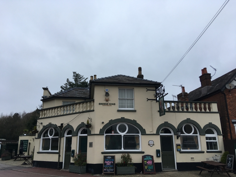
SU 41 SW PRIORY ROAD, St Denys
983/10/10029 No.21, The Junction Inn
Public House
II
Public house. Circa mid C19; remodelled later C19. Stuccoed brick. Slate hipped roof, part with parapet. Brick axial and lateral stacks. PLAN: L-shaped on plan; remodelled late C19 when a single-storey bar addition was built in the angle. EXTERIOR: 2 storeys. 3-bay south front with parapet and 4-pane sash windows on first floor; ground floor with large canted bay on left and central round-headed doorway with canopy; elliptically arched bar window on right with foiled tracery. Alternating round-arch doorways and similar elliptically arched bar windows continue to right on single-storey balustraded infil in angle with east wing. INTERIOR retains much of the late C19 public house furnishing, including an elaborate bar back and curved counter, its front boarded over later; glazed and panelled low partitions; mid C19 and early C20 chimneypieces.
Listing NGR: SU4309113650
External links are from the relevant listing authority and, where applicable, Wikidata. Wikidata IDs may be related buildings as well as this specific building. If you want to add or update a link, you will need to do so by editing the Wikidata entry.


Other nearby listed buildings
