Approximate Location Map
Large Map »
Latitude: 51.8916 / 51°53'29"N
Longitude: -2.0852 / 2°5'6"W
OS Eastings: 394232
OS Northings: 221458
OS Grid: SO942214
Mapcode National: GBR 2MB.7NP
Mapcode Global: VH947.SQZ7
Plus Code: 9C3VVWR7+MW
Entry Name: Walcot House (Number 2) and Melmerby (Number 4)
Listing Date: 12 March 1955
Grade: II
Source: Historic England
Source ID: 1388147
English Heritage Legacy ID: 476145
ID on this website: 101388147
Location: Montpellier, Cheltenham, Gloucestershire, GL50
County: Gloucestershire
District: Cheltenham
Electoral Ward/Division: Park
Parish: Non Civil Parish
Built-Up Area: Cheltenham
Traditional County: Gloucestershire
Lieutenancy Area (Ceremonial County): Gloucestershire
Church of England Parish: Leckhampton St Philip and St James
Church of England Diocese: Gloucester
Tagged with: Architectural structure
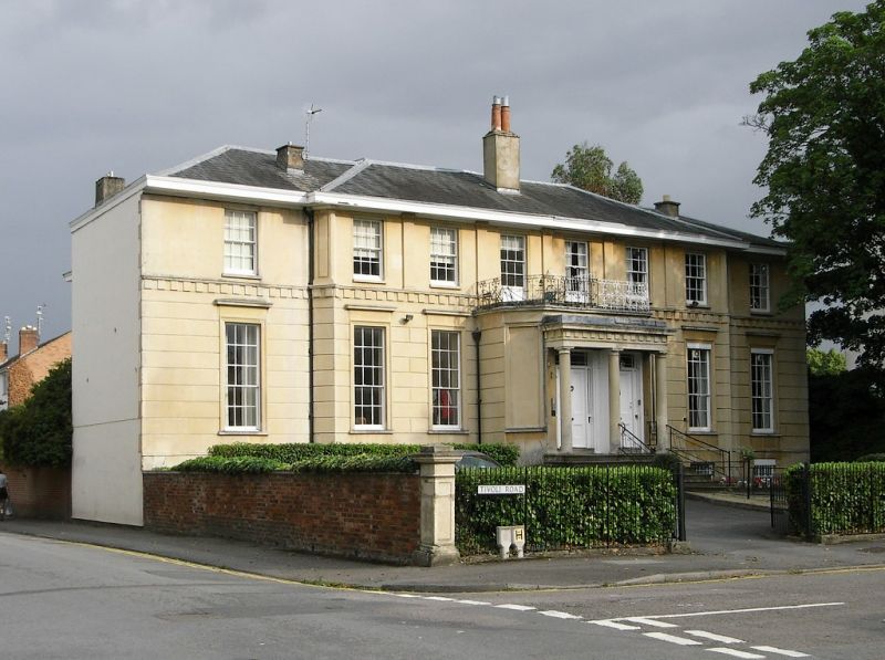
CHELTENHAM
SO9421SW TIVOLI ROAD
630-1/22/950 (East side)
12/03/55 Nos.2 AND 4
Walcot House (No.2) and Melmerby
(No.4)
GV II
Pair of semi-detached villas. c1830-40. Ashlar over brick with
hipped slate roof, stucco and brick ridge stack; iron balcony
and railings.
EXTERIOR: 2 storeys on basement, 8 first-floor windows (4:4).
Central 6-window range canted forwards, and ground-floor
entrance bay canted forwards again. Ashlar detailing includes
horizontal rustication to ground floor surmounted by modillion
band and, to first floor of centre range are Doric pilasters
to ends and between windows; windows have tooled architraves,
those to ground floor with frieze and cornice. 6/6 sashes to
first floor, tall 9/6 sashes to ground floor; all in plain
reveals. Flight of roll-edged steps to central paired
entrances, 4-panel doors (that to left part-glazed) with
shared tristyle Doric porch and entablature.
INTERIOR: photographs dated 1993 show No.2 with swept
open-well staircase with rod-and-bobbin balusters. Ceiling
friezes.
SUBSIDIARY FEATURES: balcony to porch has scrolled lozenge
motif.
HISTORICAL NOTE: houses along Tivoli Road (then known as
Tivoli) are shown as laid out on Merrett's Map of 1834, with
some to the north end built.
(The Buildings of England: Verey D: Gloucestershire: The Vale
and The Forest of Dean: London: 1970-: 154).
Listing NGR: SO9423521451
External links are from the relevant listing authority and, where applicable, Wikidata. Wikidata IDs may be related buildings as well as this specific building. If you want to add or update a link, you will need to do so by editing the Wikidata entry.


Other nearby listed buildings
