Approximate Location Map
Large Map »
Latitude: 51.9009 / 51°54'3"N
Longitude: -2.0662 / 2°3'58"W
OS Eastings: 395539
OS Northings: 222484
OS Grid: SO955224
Mapcode National: GBR 2M5.SHJ
Mapcode Global: VHB1Q.4HJ4
Plus Code: 9C3VWW2M+9G
Entry Name: 2 to 32, Victoria Place
Listing Date: 5 May 1972
Grade: II
Source: Historic England
Source ID: 1388171
English Heritage Legacy ID: 476169
ID on this website: 101388171
Location: Fairview, Cheltenham, Gloucestershire, GL52
County: Gloucestershire
District: Cheltenham
Electoral Ward/Division: All Saints
Parish: Non Civil Parish
Built-Up Area: Cheltenham
Traditional County: Gloucestershire
Lieutenancy Area (Ceremonial County): Gloucestershire
Church of England Parish: Cheltenham All Saints (Pittville)
Church of England Diocese: Gloucester
Tagged with: Building
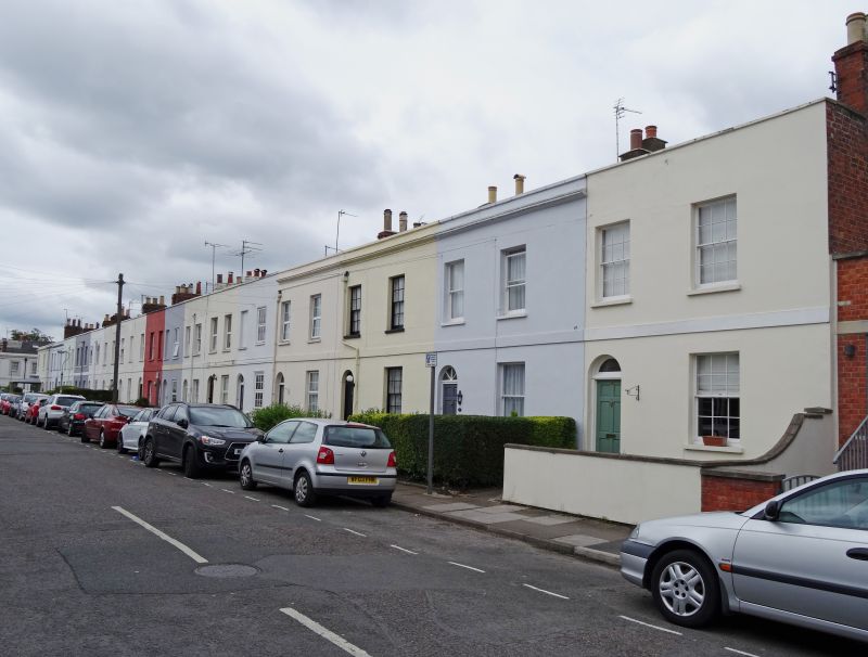
CHELTENHAM
SO9523SE VICTORIA PLACE
630-1/7/975 (West side)
05/05/72 Nos.2-32 (Even)
GV II
Terrace of 16 houses. c1830-40. Builders of Nos 2-24: Urch and
Seabright. Stucco over brick with concealed roof and brick
party-wall stacks.
EXTERIOR: 2 storeys, 2:2:3:3:3:2:2:3 otherwise 2 first-floor
windows. Stucco detailing includes first-floor band; crowning
cornice where original, blocking course and copings. 6/6 and
2/2 horizontal-pane sashes where original, some 1/1 horned
sashes, several first-floor openings are blind. All in plain
reveals and with sills. Entrances have 4-panel doors where
original, some part-glazed, with fanlights, some have radial
glazing bars, some now blocked.
INTERIOR: not inspected.
HISTORICAL NOTE: a substantially complete surviving example of
an artisan terrace. This area shown as partly built on
Merrett's Map of 1834. Other buildings by Urch and Seabright
include Nos 106-116 Fairview Road (qv).
(Blake S: 'Urch and Seabright: Cabinet-makers and Builders':
Cheltenham Local History Society Journal: 1985-: 13-23;
Merrett HS: Plan of the Town of Cheltenham: 1834-).
Listing NGR: SO9553522484
External links are from the relevant listing authority and, where applicable, Wikidata. Wikidata IDs may be related buildings as well as this specific building. If you want to add or update a link, you will need to do so by editing the Wikidata entry.


Other nearby listed buildings
