Approximate Location Map
Large Map »
Latitude: 53.2343 / 53°14'3"N
Longitude: -0.538 / 0°32'16"W
OS Eastings: 497677
OS Northings: 371803
OS Grid: SK976718
Mapcode National: GBR FMQ.8SC
Mapcode Global: WHGHZ.PYZX
Plus Code: 9C5X6FM6+PQ
Entry Name: Exchequergate
Listing Date: 8 October 1953
Last Amended: 20 December 1999
Grade: I
Source: Historic England
Source ID: 1388541
English Heritage Legacy ID: 485986
ID on this website: 101388541
Location: Lincoln, Lincolnshire, LN2
County: Lincolnshire
District: Lincoln
Electoral Ward/Division: Minster
Parish: Non Civil Parish
Built-Up Area: Lincoln
Traditional County: Lincolnshire
Lieutenancy Area (Ceremonial County): Lincolnshire
Church of England Parish: Lincoln, St Mary Magdalene with St Paul in the Bail and St Michael on the Mount
Church of England Diocese: Lincoln
LINCOLN
SK9771NE EXCHEQUERGATE
1941-1/9/254 (West side)
08/10/53 Exchequergate
(Formerly Listed as:
MINSTER YARD
Exchequergate)
GV I
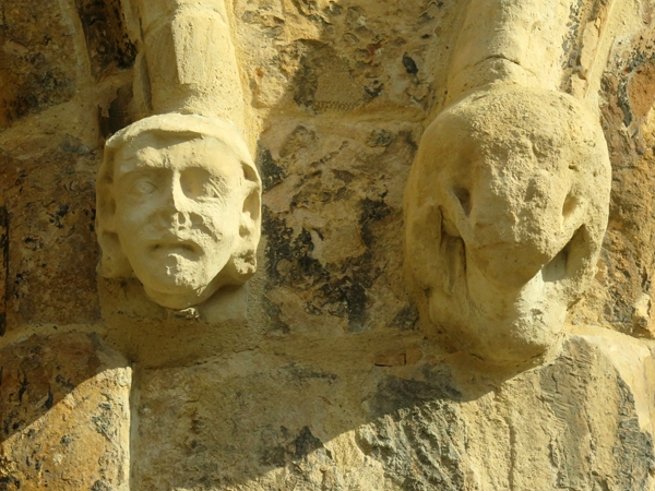
West gatehouse to the Close wall. Mid C14. Restored C19.
Ashlar with asphalt roof. Chamfered plinth, 2 string courses,
coped parapet and gables with finials.
3 storeys, 5 bays. East front has a central moulded archway
flanked by turrets with crenellated tops. Beyond, single
smaller archways and single lancet windows. All these openings
have hoodmoulds and mask stops. Above each of the 3 archways,
a canopied niche. Beyond, on either side, a single lancet with
hoodmould. Above again, a small central loop, and beyond,
foiled single lancets.
West side has a similar central arch flanked by 2-light
pointed arched windows, and beyond, smaller arches, all with
linked hoodmoulds. To the left, at a higher level, a smaller
plain lancet. Above, a central canopied niche, flanked by
single loops, and beyond, 2-light pointed arched windows.
Above again, 5 smaller 2-light pointed arched windows. Under
the archways, stone diagonal rib vaults with bosses and brick
cells, chamfered doorways, and paired shouldered openings for
shops, now blocked.
INTERIOR not inspected.
As well as serving as a gateway, this building formerly
contained a number of rented shops. A western gateway was
demolished between c1796 and c1816.
(Buildings of England : Lincolnshire: Pevsner N: Lincolnshire:
London: 1989-: 484; Jones S: The Survey of Ancient Houses in
Lincoln: Lincoln: 1987-: 91-101).
Listing NGR: SK9767771803
External links are from the relevant listing authority and, where applicable, Wikidata. Wikidata IDs may be related buildings as well as this specific building. If you want to add or update a link, you will need to do so by editing the Wikidata entry.


Other nearby listed buildings
