Approximate Location Map
Large Map »
Latitude: 52.1985 / 52°11'54"N
Longitude: -2.2244 / 2°13'27"W
OS Eastings: 384756
OS Northings: 255611
OS Grid: SO847556
Mapcode National: GBR 1G4.2FX
Mapcode Global: VH92T.D0DF
Plus Code: 9C4V5QXG+C6
Entry Name: 29, the Tything
Listing Date: 22 May 1954
Grade: II
Source: Historic England
Source ID: 1390218
English Heritage Legacy ID: 489188
ID on this website: 101390218
Location: Britannia Square, Worcester, Worcestershire, WR1
County: Worcestershire
District: Worcester
Electoral Ward/Division: Cathedral
Parish: Non Civil Parish
Built-Up Area: Worcester
Traditional County: Worcestershire
Lieutenancy Area (Ceremonial County): Worcestershire
Church of England Parish: Worcester St George with St Mary Magdalene
Church of England Diocese: Worcester
Tagged with: Building
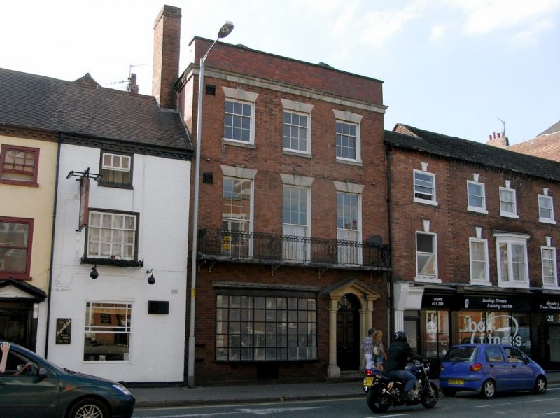
WORCESTER
SO8455NE THE TYTHING
620-1/8/631 (West side)
22/05/54 No.29
GV II
House, now offices, part of terrace. c1820. Red brick with
stone detailing. 2-span hipped slate roof with ridges running
at right-angles to street, concealed by high rebuilt parapet
wall. Rebuilt chimney stack with oversailing detail to left.
Cast-iron brackets and wrought-iron balustrade to balcony.
Narrow burgage plot with entrance to right.
3 storeys. 3 first-floor windows. tone detailing includes
plain frieze and moulded cornice; sills and wedge lintels with
capped projecting keystones to window openings; entrance steps
and doorcase. Tall 6/6 sashes to first-floor access full-width
balcony; balustrade incorporates anthemion and scroll
decoration. 3/6 sashes to second-floor, all upper floor
windows in plain reveals. 2 steps to 6-panel door; radial
pattern fanlight; Tuscan-style doorcase with open pediment.
Brickwork to ground-floor and window to left of entrance date
from second-half of C20.
INTERIOR: not inspected.
External links are from the relevant listing authority and, where applicable, Wikidata. Wikidata IDs may be related buildings as well as this specific building. If you want to add or update a link, you will need to do so by editing the Wikidata entry.


Other nearby listed buildings
