Approximate Location Map
Large Map »
Latitude: 51.5176 / 51°31'3"N
Longitude: -0.289 / 0°17'20"W
OS Eastings: 518812
OS Northings: 181235
OS Grid: TQ188812
Mapcode National: GBR 7X.3SN
Mapcode Global: VHGQW.Y31Z
Plus Code: 9C3XGP96+29
Entry Name: North Ealing Station, Including Footbridge
Listing Date: 30 October 2003
Grade: II
Source: Historic England
Source ID: 1390751
English Heritage Legacy ID: 491323
Also known as: North Ealing Underground station
ID on this website: 101390751
Location: West Acton, Ealing, London, W5
County: London
District: Ealing
Electoral Ward/Division: Hanger Hill
Parish: Non Civil Parish
Built-Up Area: Ealing
Traditional County: Middlesex
Lieutenancy Area (Ceremonial County): Greater London
Church of England Parish: The Ascension, Hanger Hill
Church of England Diocese: London
Tagged with: London Underground station
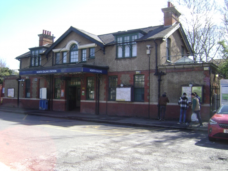
962/0/10075 STATION ROAD
30-OCT-03 North Ealing Station, including
Footbidge
II
Underground Station. 1899 by the District Railway, but opened only on 23 June 1903 after electric traction had been installed. Roughcast brick, with red brick and stone dressings on red-brick plinth, slate roof with red brick stacks. The main building is on the west side of the tracks, rectangular and of two storeys, with booking hall. A bridge leads to the eastbound platform, which is served by a timber shelter.
Main building is a symmetrical composition to entrance frontage (car park), with small projecting canopy on cast-iron brackets and with dentilled cornice. Gable above on timber brackets with Venetian window in centre, flanked by smaller openings, one now partly blocked. The upper floor has sash windows with small panes in the upper sashes, set into gables and dormers. Small panes throughout to the sashes on the lower floor. Double doors with small lights to upper section leads to central booking hall, with ticket office to left and office to right, retaining clock. Steps down to platform level pass under sign (TO TRAINS FOR HARROW AND UXBRIDGE) in heavy type with finger pointer, an early example of the standardised signage which Edward Johnson began to introduce after 1915. Canopy to rear elevation, then a separate platform canopy at bottom of steps, supported on timber posts and steel brackets, and with timber cheeks and bargeboards. Wrought-iron lattice girder footbridge with added roof. Smaller timber shelter on 'up' platform with proportionately large canopy and bargeboards.
North Ealing is the only station to survive from the era of the District Railway's westward expansion in 1899-1903, and is an extremely unaltered and unusually richly detailed example of a station from this era.
Source
Laurence Menear, London's Underground Stations, London, Midas Books, 1983.
External links are from the relevant listing authority and, where applicable, Wikidata. Wikidata IDs may be related buildings as well as this specific building. If you want to add or update a link, you will need to do so by editing the Wikidata entry.


Other nearby listed buildings
