Latitude: 51.565 / 51°33'53"N
Longitude: -0.093 / 0°5'34"W
OS Eastings: 532275
OS Northings: 186847
OS Grid: TQ322868
Mapcode National: GBR GJ.570
Mapcode Global: VHGQM.BXPN
Plus Code: 9C3XHW74+XQ
Entry Name: Walls and Railings to Former Metropolitan Water Board Pumping Station; West Side of Green Lanes from K2 Kiosk North for 15 Bays; East Side of Green Lanes from Boundary with 212 Green Lanes North for 1
Listing Date: 22 June 2004
Grade: II
Source: Historic England
Source ID: 1390859
English Heritage Legacy ID: 491434
ID on this website: 101390859
Location: Climbing Centre, Brownswood Park, Hackney, London, N4
County: London
District: Hackney
Electoral Ward/Division: Brownswood
Parish: Non Civil Parish
Built-Up Area: Hackney
Traditional County: Middlesex
Lieutenancy Area (Ceremonial County): Greater London
Church of England Parish: St Mary Stoke Newington
Church of England Diocese: London
Tagged with: Wall
735/0/10163 GREEN LANES
22-JUN-04 Walls and Railings to former Metropoli
tan Water Board pumping station; WEST
side of Green Lanes from K2 kiosk nort
h for 15 bays; EAST side of Green Lane
s from boundary with 212 Green Lanes n
orth for 13 bays
GV II
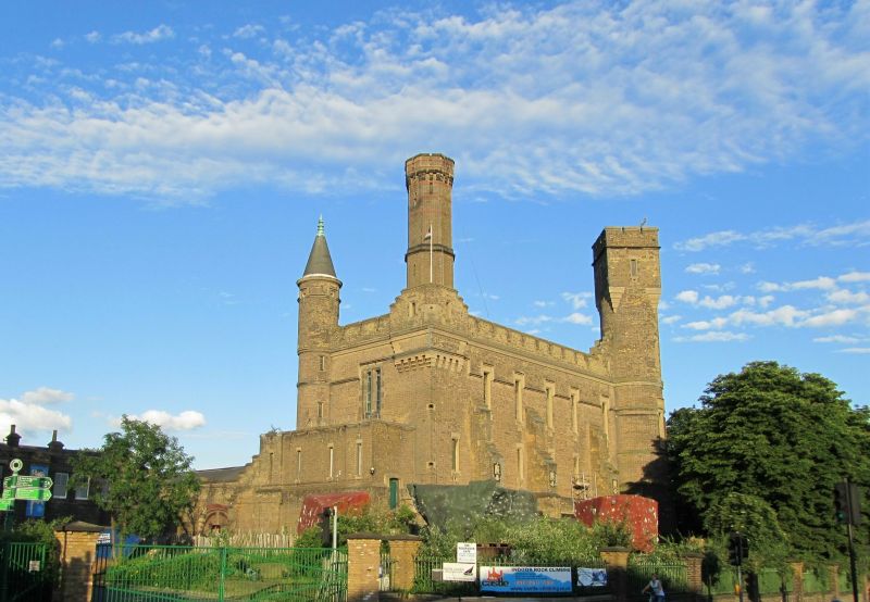
Boundary wall and railings to former pumping station. c1870s for the New River Company. Stock brick in Flemish bond with blue brick plinths, stone capping, and iron railings. Walls comprise brick piers with corbelled tops and pyramidal stone caps, linked by low brick wall blue brick plinth and stone cill under iron railings with spear heads. The walls run parallel to the east and west sides of Green Lanes and the listing includes: west side from the K2 kiosk (q.v.) north for 15 bays; east side from the boundary with No.212 north for 13 bays. The wall that continues to the north has been substantially rebuilt and this is not included in the listing.
HISTORY: The Pumping Station (q.v., II*) was built 1854-6 to the designs of W. Chadwell Mylne in an picturesque medieval fortress style. The boundary wall and railings first appear on a map of 1883. This was the site of the 1830s New River reservoirs, with filter beds added from 1855. The Metropolitan Water Board was established in 1902 at which time the undertakings of the New River Company were transferred.
Listed as the intact section of Victorian brick boundary wall with iron railings that has good group value with the Grade II* former Engine House and Ancilliary Building.
External links are from the relevant listing authority and, where applicable, Wikidata. Wikidata IDs may be related buildings as well as this specific building. If you want to add or update a link, you will need to do so by editing the Wikidata entry.


Other nearby listed buildings