Latitude: 51.6717 / 51°40'17"N
Longitude: -0.06 / 0°3'35"W
OS Eastings: 534249
OS Northings: 198769
OS Grid: TQ342987
Mapcode National: GBR HZ.7K1
Mapcode Global: VHGQ7.X74V
Plus Code: 9C3XMWCR+M2
Entry Name: Maidens Bridge
Listing Date: 23 August 2005
Grade: II
Source: Historic England
Source ID: 1391507
English Heritage Legacy ID: 493788
ID on this website: 101391507
Location: Bulls Cross, Enfield, London, EN2
County: London
District: Enfield
Electoral Ward/Division: Chase
Parish: Non Civil Parish
Traditional County: Middlesex
Lieutenancy Area (Ceremonial County): Greater London
Church of England Parish: Jesus Church Forty Hill
Church of England Diocese: London
Tagged with: Bridge Road bridge
790/0/10099 FORTY HILL
23-AUG-05 Maiden's Bridge
II
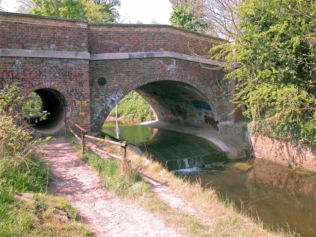
Road bridge across Maiden's Brook,Circa 1800, Architect unknown
Materials: London stock brick with stone dressings
Description: Single span bridge flanked by circular flood arches. Projections to form four narrow pedestrian refuges. Stone string course and copings to parapets. Terminals to iron ties either side of principal arch. Iron plaque on east elevation of west parapet. Inscription reads: County of Middlesex. Take notice that this bridge (which is a county bridge) is insufficient to carry weights beyond the ordinary traffic of the District and that the owners and persons in charge of locomotive traction engines and heavily laden carriages are warned against using the bridge for the passage of any such engines or carriages. Richard Nicholson, Clerk of the Peace. Brick paved stream bed beneath principal arch with iron retaining plate to east. Bank retaining walls of brick immediately adjoining bridge.
History: The bridge is the final such in a sequence believed to have occupied the site since before the Norman Conquest and was built to replace the earlier timber and brick bridge which had proved too narrow. Robinson, in his history of Enfield (1823), reports that `this bridge was built of brick, the whole width of the road, about twenty years ago.' The present plaque dates to the early 20th century replacing one of circa 1824 which threatened anyone damaging the bridge with deportation for life. Some parapet rebuilding of 1968 after the bridge was struck by a lorry, which prompted the current single flow traffic system.
Maiden's Bridge is a simple yet attractively composed structure of circa 1800 which still performs the function for which it was constructed.
Sources
Carter, V (ed.), 2000
Treasures of Enfield. Pages 58-9
Cherry, B & Pevsner, N, 1999
The Buildings of England. London 4: North. Page 450
Koch, E, 1935
Forty Hill Church and Parish
Robinson, W, 1823
History and antiquities of Enfield
Whitaker, C, 1911
An illustrated history, statistical and topopographical account of Enfield
External links are from the relevant listing authority and, where applicable, Wikidata. Wikidata IDs may be related buildings as well as this specific building. If you want to add or update a link, you will need to do so by editing the Wikidata entry.


Other nearby listed buildings