Latitude: 52.7937 / 52°47'37"N
Longitude: -3.0731 / 3°4'23"W
OS Eastings: 327733
OS Northings: 322337
OS Grid: SJ277223
Mapcode National: GBR 72.X409
Mapcode Global: WH794.R1SK
Plus Code: 9C4RQWVG+FP
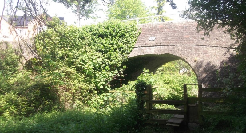
Entry Name: Pant Bridge
Listing Date: 16 August 2006
Grade: II
Source: Historic England
Source ID: 1391729
English Heritage Legacy ID: 495857
ID on this website: 101391729
Location: Pant, Shropshire, SY10
County: Shropshire
Civil Parish: Llanymynech and Pant
Built-Up Area: Pant
Traditional County: Shropshire
Lieutenancy Area (Ceremonial County): Shropshire
Church of England Parish: Morton St Philip and St James
Church of England Diocese: Lichfield
Tagged with: Bridge
LLANYMYNECH AND PANT
1574/0/10012 Pant Bridge 16-AUG-06
II
Bridge. 1794-1797. Designed and constructed by William Jessop and Thomas Telford. The canal bridge is constructed entirely with red brick with a chamfered stone coping. A string course which continues to piers at the eastern end is truncated by the stone built tramway extension on the western side. The canal and associated brick with stone coping tow path runs under the bridge's segmental arch. The tramway span also has a brick lined segmental arch although the remaining fabric is of stone topped by a dressed stone chamfered coping. This part of the bridge is slightly wider than the earlier element which spans the canal.
History The arched brick bridge (no. 88) over the Montgomery Canal at Pant was built when the Llanymynech branch of the Ellesmere Canal was constructed to serve the major lime workings at Llanymynech, about a mile to the south of this bridge. This canal became part of the Shropshire Union in 1846 and remained in use until 1936. Subsequently, a further mainly stone built span was attached to the original western end of the canal bridge to accommodate a tramway leading from Pant Quarry to a small wharf situated immediately to the south.
Summary of Importance The bridge at Pant forms an integral part of an important industrial landscape which was created in the latter years of the C18 and early years of C19. The bridge survives well and contributes to our understanding and appreciation of early transport systems.
Sources www.waterscape.com www.canaljunction.com/canal/montgomery.htm
Listing NGR: SJ 2773022339
External links are from the relevant listing authority and, where applicable, Wikidata. Wikidata IDs may be related buildings as well as this specific building. If you want to add or update a link, you will need to do so by editing the Wikidata entry.


Other nearby listed buildings