Latitude: 53.5409 / 53°32'27"N
Longitude: -2.8414 / 2°50'28"W
OS Eastings: 344340
OS Northings: 405248
OS Grid: SD443052
Mapcode National: GBR 8WLH.ND
Mapcode Global: WH86Q.B869
Plus Code: 9C5VG5R5+9F
Entry Name: Bickerstaffe Stocks
Listing Date: 5 June 2007
Grade: II
Source: Historic England
Source ID: 1392018
English Heritage Legacy ID: 503011
ID on this website: 101392018
Location: Stanley Gate, West Lancashire, L39
County: Lancashire
District: West Lancashire
Civil Parish: Bickerstaffe
Traditional County: Lancashire
Lieutenancy Area (Ceremonial County): Lancashire
Church of England Parish: Bickerstaffe Holy Trinity
Church of England Diocese: Liverpool
Tagged with: Architectural structure
BICKERSTAFFE
1283/0/10045 ORMSKIRK ROAD
05-JUN-07 Stanley Gate
Bickerstaffe Stocks
II
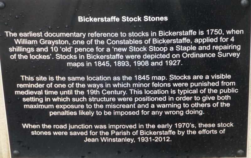
A set of stocks first documented in 1750 but thought to be earlier.
MATERIALS: Sandstone pillars with modern timber planks.
EXTERIOR: The stocks consist of two rectangular round-headed sandstone pillars about 1m tall, slotted on the inside, with modern timber planks containing two ankle holes. One of the stone pillars has an Ordnance Survey bench mark inscribed at the top and both pillars display some tool marks. The upper part of both pillars is more weathered than the lower part, indicating that they were once inserted into the ground to a greater depth than at present.
HISTORY: The earliest documentary reference of the existence of the Bickerstaffe stocks is a copy of `The Accompts kept by William Grayston, one of the Constables of Bickerstaffe, the year 1750', which includes the phrase, `To a new Stock Stoop a Staple and repairing of the lockes - 0. 4s. 10d.' This suggests that the stocks were already in existence by 1750. The stocks are depicted on First Edition Ordnance Survey map of 1845 and on subsequent maps of 1893, 1908 and 1927 and are still to be found at the same location as recorded on the 1845 map. The modern map, however, describes them as `Stocks (remains of)'. New timbers have been inserted recently and work has been carried out by the Parish Council in 2006 to tidy up the site of the stocks and the immediate surroundings.
SOURCES: Letter from West Lancashire Civic Trust, 16-12-2006.
Letter from West Lancashire District Council, 19-2-2007.
SUMMARY OF IMPORTANCE: Bickerstaffe stocks were documented as being in existence in the mid C18 and map evidence shows that they have occupied their present position since at least 1845. They are a visible reminder of one of the ways in which minor felons were punished from medieval times until the C19. The location of these stocks at a major crossroad in Bickerstaffe village is typical of the public setting in which such structures were positioned in order to give both maximum exposure to the miscreant and a warning to others of the penalties likely to be imposed for any wrongdoing.
External links are from the relevant listing authority and, where applicable, Wikidata. Wikidata IDs may be related buildings as well as this specific building. If you want to add or update a link, you will need to do so by editing the Wikidata entry.


Other nearby listed buildings