Approximate Location Map
Large Map »
Latitude: 52.9919 / 52°59'30"N
Longitude: -1.0175 / 1°1'2"W
OS Eastings: 466046
OS Northings: 344292
OS Grid: SK660442
Mapcode National: GBR 9JP.FKR
Mapcode Global: WHFHZ.B2Q5
Plus Code: 9C4WXXRM+Q2
Entry Name: Bulcote Corporation Model Farm
Listing Date: 10 February 2005
Grade: II
Source: Historic England
Source ID: 1392070
English Heritage Legacy ID: 492942
ID on this website: 101392070
Location: Bulcote, Newark and Sherwood, Nottinghamshire, NG14
County: Nottinghamshire
District: Newark and Sherwood
Civil Parish: Bulcote
Built-Up Area: Burton Joyce
Traditional County: Nottinghamshire
Lieutenancy Area (Ceremonial County): Nottinghamshire
Church of England Parish: Burton Joyce with Bulcote and Stoke Bardolph
Church of England Diocese: Southwell and Nottingham
Tagged with: Agricultural structure
1163/0/10015
10-FEB-05
BULCOTE
Bulcote Corporation Model Farm
GV
II
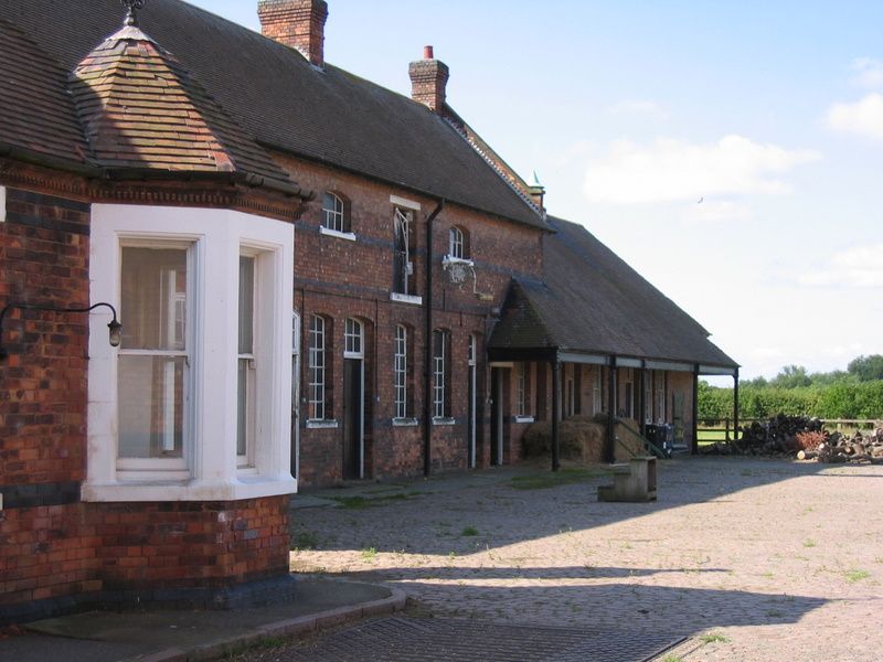
Farm buildings. 1902. Designed by the Nottingham City Engineer Arthur Brown. Red brick with blue brick bands and cill bands plus ashlar dressings. Plain tile roofs with various ridge stacks. Quadrangular plan. Metal framed windows with central opening casements. Segment headed windows throughout. Fire-proofed brick arched floor construction throughout with concrete floors.
North-west and north-east ranges two storeys. North-east stable range has recessed centre with 20 bays divided by pilaster strips. Every fourth bay has a tall glazing bar window with a smaller window above, and every intermediary bay has a single smaller window above. Three window projecting block to left has large glazing bar windows with smaller windows above, five window projecting block to right has five large glazing bar windows with above a central taking-in door with a single smaller window to left and two to right. To south a set of ornate iron gates with gabled iron gatepiers linking to single storey office building.
Office building has two tall brick chimney stacks, a metal roof ventilator and plate-glass sash windows throughout. Street front has a double and two single sashes. Gabled south-east facade has two pairs of sashes and a door to left gable and a large triple sash to right gable. Main courtyard front has octagonal corner bay window topped with an iron weather vane. To left a door flanked by single sashes and beyond a pair of sashes. In front of this facade a 15 ton weigh-bridge made by W & T Avery Ltd, London & Birmingham.
South-east stable range two storey and single dairy range to right. Stable range has 12 bays with alternating doors and windows from left, above a taking-in door and three small windows. Dairy to right has deeply overhanging roof supported on circular cast-iron columns. Seven bays, from left a glazing bar sash then a doorway, two further sashes, another double door and another two sashes beyond.
Two ten bay pig sty ranges to south-west, single storey with slate roofs. Both main fronts have ten small glazing bar windows and ten roof-lights. Rear facades have ten small segment arched doorways. Gable ends have irregular roofline with single doorways, these doorways lead into corridors which serve the individual sties. These corridors have narrow gauge railway-lines for feeding trucks.
Both these ranges have similar facades to inner courtyard.
North-west storage range has 20 bays with 13 large glazing bar windows which alternate irregularly with three cart entrances and a broad entrance to the inner courtyard. Beyond to right a later C20 extension, not of special interest.
To north-west two specialist single storey buildings with large glazing bar windows with segment heads.
This an important example of an industrial farmyard. It was constructed specifically by Nottingham City Corporation in order to assist with the dispersal of the solid waste produced by the sewage works at Stoke Bardolph.
External links are from the relevant listing authority and, where applicable, Wikidata. Wikidata IDs may be related buildings as well as this specific building. If you want to add or update a link, you will need to do so by editing the Wikidata entry.


Other nearby listed buildings
