Approximate Location Map
Large Map »
Latitude: 53.1812 / 53°10'52"N
Longitude: -1.8692 / 1°52'8"W
OS Eastings: 408841
OS Northings: 364908
OS Grid: SK088649
Mapcode National: GBR 358.G8P
Mapcode Global: WHCDB.895K
Plus Code: 9C5W54JJ+F8
Entry Name: Milestone South of Longnor Market Place
Listing Date: 30 April 2008
Grade: II
Source: Historic England
Source ID: 1392589
English Heritage Legacy ID: 503381
ID on this website: 101392589
Location: Longnor, Staffordshire Moorlands, Staffordshire, SK17
County: Staffordshire
District: Staffordshire Moorlands
Civil Parish: Longnor
Traditional County: Staffordshire
Lieutenancy Area (Ceremonial County): Staffordshire
Church of England Parish: Longnor St Bartholomew
Church of England Diocese: Lichfield
Tagged with: Milestone
418/0/10004
30-APR-08
LONGNOR
B5053
Milestone South of Longnor Market Place
II
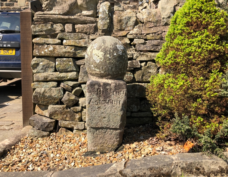
An early C18 stone waymarker with later ball finial. The south facing side reads BAKEWELL (with hand pointing to the right) LEEK (with hand pointing to the left). The east facing side reads BUXTON (with hand pointing to the right) ASHBURN with hand pointing to the left). The north facing side reads LEEK (with hand pointing to the right) BAKEWELL (with hand pointing to the left). The hands used to depict the respective directions are gauntlet clad.
HISTORY: This stone waymarker is believed to have been erected between 1709 and 1711 and therefore predates the later C18 expansion in the formal road network as a result of the introduction of turnpike legislation.
REASONS FOR DESIGNATION DECISION
Stone waymarker south of Longnor Market Place is designated at Grade II, for the following principal reasons:
* A particularly well preserved example of an early C18 stone waymarker
* It stands in close proximity to a large number of listed buildings including a cross
* It is similar in character to the distinctive Derbyshire guide stoops
* A particularly well preserved example of an early C18 stone waymarker
* It stands in close proximity to a large number of listed buildings including a cross
* It is similar in character to the distinctive Derbyshire guide stoops
External links are from the relevant listing authority and, where applicable, Wikidata. Wikidata IDs may be related buildings as well as this specific building. If you want to add or update a link, you will need to do so by editing the Wikidata entry.


Other nearby listed buildings
