Latitude: 52.5893 / 52°35'21"N
Longitude: -1.9757 / 1°58'32"W
OS Eastings: 401740
OS Northings: 299055
OS Grid: SP017990
Mapcode National: GBR 2G0.MP
Mapcode Global: WHBG1.M5CT
Plus Code: 9C4WH2QF+PP
Entry Name: Queen Mary's Grammar School Buildings
Listing Date: 27 May 2005
Grade: II
Source: Historic England
Source ID: 1392787
English Heritage Legacy ID: 491900
ID on this website: 101392787
Location: Ryecroft, Walsall, West Midlands, WS4
County: Walsall
Electoral Ward/Division: St Matthew's
Parish: Non Civil Parish
Built-Up Area: Walsall
Traditional County: Staffordshire
Lieutenancy Area (Ceremonial County): West Midlands
Church of England Parish: Walsall St Paul
Church of England Diocese: Lichfield
Tagged with: Building
WALSALL
1690/0/10053 LICHFIELD STREET
27-MAY-05 Queen Mary's Grammar School Buildings
II
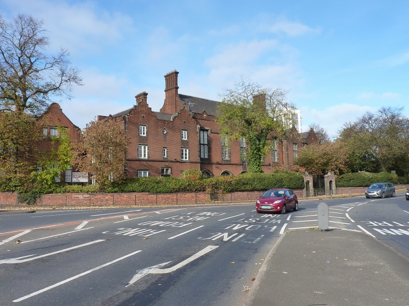
School. 1850. Edward Adams. Red Flemish bond brick with stone dressings and a plain tile roof. "Tudorbethan". I-shaped plan of 2 and 3 storeys with central schoolroom range. The entrance front is symmetrical to the road with 5 central bays. These have 4-centered arches to the ground floor with hood moulds which originally formed an open colonnade, but were glazed in the C20. Above are the large cross-windows of the school room with ashlar surrounds and 4-centered heads to the lights which are connected by a continuous hood-mould. Below the central window is a stone plaque which states in relief in Gothic script: "The Grammar School/founded by Queen Mary/AD 1554./Rebuilt/AD 1849." There is a brick parapet to the top of the wall with a gablet above each bay. This central block has a seperate longitudinal roof with shaped gables at either side which have large chimney stacks to their centres. Slightly projecting at either side are 3-storey wings which each have 2 shaped gables facing the road. Contemporary etchings show that the wings were originally similar and followed the pattern of the former headmaster's house in the left hand wing which has a central doorway with 4-centered head flanked by 2-light casements. To the first floor are similar windows at either side of a narrow single-light and to the second floor are 2 similar windows at either side of a diamond-shaped light. The right wing now has two floors and 2 long windows to either side of a central, single light. There is a substantial wing to the rear added in the later C19 which is not included with this item and a C20 metal-clad stair tower which is similarly excluded. The rear has several, original, metal-framed lattice windows.
Interior: The former headmaster's house has cornicing to two ground floor rooms and central ceiling roses. The colonnade has been converted to a canteen. The Schoolroom at first floor level has a panelled roof with braces consisting of corbels supporting wall posts and arched braces connected to scissor beams.
History: A boy's grammar school was founded in 1554 and endowed with some 300 acres. In 1838 the school was divided into two parts with the grammar school accompanied by a commercial school. From 1847 the school occupied the grandstand on the town's racecourse and then in 1850 moved to the present premises designed by Edward Adams, a local architect and former pupil of the school. In 1873 the school's property was vested in the charity commissioners and it became non-denominational. From this same date girls were educated in an adjacent building called Queen Mary's High School for Girls. In 1965 a separate boys' school was built at Mayfield and the buildings which are the subject of this application were handed over to the girls' school.
Source: Victoria County History, Staffordshire, Vol VI, pp. 174-176.
External links are from the relevant listing authority and, where applicable, Wikidata. Wikidata IDs may be related buildings as well as this specific building. If you want to add or update a link, you will need to do so by editing the Wikidata entry.


Other nearby listed buildings