Latitude: 52.4898 / 52°29'23"N
Longitude: -1.9124 / 1°54'44"W
OS Eastings: 406043
OS Northings: 287988
OS Grid: SP060879
Mapcode National: GBR 5X5.MC
Mapcode Global: VH9YW.SPV6
Plus Code: 9C4WF3QQ+W2
Entry Name: 87, 88 and 88A, Vyse Street
Listing Date: 29 April 2004
Grade: II
Source: Historic England
Source ID: 1392825
English Heritage Legacy ID: 505866
ID on this website: 101392825
Location: Hockley, Birmingham, West Midlands, B18
County: Birmingham
Parish: Non Civil Parish
Built-Up Area: Birmingham
Traditional County: Warwickshire
Lieutenancy Area (Ceremonial County): West Midlands
Church of England Parish: Birmingham St Paul
Church of England Diocese: Birmingham
Tagged with: Building
BIRMINGHAM
997/0/10316
29-APR-04
VYSE STREET
87, 88 AND 88A
GV
II
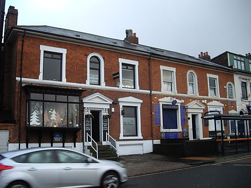
A pair of manufactories. Mid-C19, adapted and enlarged by late C19, further altered late C20.
Red brick with painted stone dressings, truncated central ridge stack and a hipped roof with composition slate covering.
PLAN: Long street frontage formed by pair of double-fronted former dwellings with added parallel rear workshop ranges enclosing narrow yards.
EXTERIOR: 7-bay frontage range of 2 storeys , No. 87 with basement, the smaller right-hand end bay possibly a passage to rear workshops. Remaining 6 bays form near-symmetrical facade with 2 central doorways between flanking windows. Doorways below pediments with altered pilaster doorcases. 4-panel doors, that to No. 88 within a panelled reveal. Left-hand part with ground floor display bay window on elaborate moulded brackets, and with dentilled cornice. Right-hand window with shallow -pitched lintel and undivided sash frame. Wider, similarly - detailed openings to right-hand part with C20 joinery.
First floor windows set upon a painted sill band, with rectangular surrounds to outer openings and semi-circular arch-headed openings to the centre, above each doorway. At right-hand end, a lower semi-circular headed window with glazing bars. Rear elevation to No. 88, with added storeyed workshop range
INTERIOR : Workshop range to No. 88 with composite metal and timber roof structure supported on one side by brick piers and on the other by cast-iron columns. Evidence of floor level line shafting survives.
HISTORY: The buildings were apparently built as houses, and appear as such on the Piggot-Smith map of 1855-62. On the 1889 Ordnance Survey map, a long dog-legged range is shown attached to the rear of No.87, and the rear yard of No. 88 sub-divided. The workshop range at No.88 was added between 1887 and 1907.
A mid-C19 pair of small evolved manufactories, originally houses, but rapidly adapted and extended to form industrial premises during the expansion of a notable manufacturing quarter of Birmingham now recognised as being of international significance.
External links are from the relevant listing authority and, where applicable, Wikidata. Wikidata IDs may be related buildings as well as this specific building. If you want to add or update a link, you will need to do so by editing the Wikidata entry.


Other nearby listed buildings