Approximate Location Map
Large Map »
Latitude: 52.4195 / 52°25'10"N
Longitude: -2.2366 / 2°14'11"W
OS Eastings: 384008
OS Northings: 280193
OS Grid: SO840801
Mapcode National: GBR 1CD.CCJ
Mapcode Global: VH91N.5GZ2
Plus Code: 9C4VCQ97+Q9
Entry Name: Debdale Lock and Associated Weir, and Cave
Listing Date: 15 October 2009
Grade: II
Source: Historic England
Source ID: 1393486
English Heritage Legacy ID: 507117
ID on this website: 101393486
Location: Cookley, Wyre Forest, Worcestershire, DY10
County: Worcestershire
District: Wyre Forest
Civil Parish: Wolverley and Cookley
Traditional County: Worcestershire
Lieutenancy Area (Ceremonial County): Worcestershire
Church of England Parish: Kidderminster Ismere
Church of England Diocese: Worcester
Tagged with: Lock
WOLVERLEY AND COOKLEY
1805/0/10037 COOKLEY
15-OCT-09 Debdale Lock and associated weir, and
cave
II
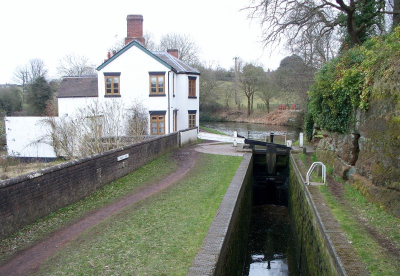
Lock, circular weir and cave at Debdale forming part of the Staffordshire and Worcestershire Canal,which opened to traffic in 1772 and was designed by James Brindley (1716-72).
LOCK: Narrow lock, built to the design of James Brindley in around 1770. The lock chamber is rockcut and brick faced with a replacement engineering brick coping. The eastern (upper) wooden gate has a timber balance beam and ground paddle gears. The western (lower) end is denoted by a pair of wooden lock gates with gate paddles and timber balance beams. The rock cliff face adjacent to both lock gates has been roughly quarried to accommodate the moving balance beams. The surfaces
adjacent to the balance beams are of modern brick, but original sandstone surfaces may survive below. A small upright pillar situated a short distance to the south of the lock may be a mile post or bollard. Rubbing marks formed by ropes are visible on its surface.
WEIR: Circular weir, built to the design of James Brindley in around 1770. The weir is surrounded by a nearly circular brick wall with half round coping, probably added in the C19. This wall surrounds an overflow channel leading underground from the canal. Water from the channel cascades over a low brick built wall and two overspills into a central plunge hole which is covered by a modern protective metal cage. The weir is an overflow device for ensuring the canal water levels remain stable.
CAVE: Artificial cave cut into the north facing sandstone cliff adjacent to Debdale Lock in around 1770. Access to the cave is provided by a round arched doorway which retains a rock-cut door frame slot. The interior of the cave measures approximately 9m long by 3m wide and the roof is up to 2.5m high. A
stone cut bench leads around the entire edge of the cave and this is up to 0.5m high. The cave walls retain tool marks formed during the rough dressing of its surface.
HISTORY
The Staffordshire and Worcestershire Canal was designed by one of the most prominent C18 canal engineers, James Brindley (1716-72), and was fully opened to traffic in May 1772. It formed part of a grand scheme to link Hull, Liverpool and Bristol by connecting the Rivers Mersey, Trent and Severn. The canal is 75 kilometres long, has 43 locks and runs from Great Heywood, where it meets the Trent and Mersey Canal to Stourport, where it joins the River Severn. The canal was a success and despite intermittent threats from neighbouring companies, remained in active commercial use until the closure of the Stourport power station in 1949. In 1963 the canal was classified under the Transport Act as a
cruiseway and remains a popular recreational resource. All the structures at Debdale were probably originally built around 1770.
A footbridge (c.1772) to a design by James Brindley, with brick and sandstone abutments, modern timber deck and parapet rails, is not of special interest.
SOURCES
The Transport Buildings Selection Guide published by English Heritage, Heritage Protection Department (March 2007)
REASONS FOR DESIGNATION
Debdale Lock, weir and cave are designated at Grade II for the following principal reasons:
* As good examples of canal structures from the earliest, pioneering phase of canal building
* All from part of the Staffordshire and Worcestershire canal, designed by by the prominent C18 canal engineer, James Brindley
* As a good group of canal structures which includes rare or unusual features such as the circular weir and cave
Debdale Lock, weir and cave are designated at Grade II for the following principal reasons:
* As good examples of canal structures from the earliest, pioneering phase of canal building
* All form part of the Staffordshire and Worcestershire canal, designed by the prominent C18 canal engineer, James Brindley
* As a good group of canal structures which includes rare or unusual features such as the circular weir and cave
External links are from the relevant listing authority and, where applicable, Wikidata. Wikidata IDs may be related buildings as well as this specific building. If you want to add or update a link, you will need to do so by editing the Wikidata entry.


Other nearby listed buildings
