Latitude: 51.1205 / 51°7'13"N
Longitude: 1.3115 / 1°18'41"E
OS Eastings: 631839
OS Northings: 140904
OS Grid: TR318409
Mapcode National: GBR X2Z.NDM
Mapcode Global: VHLHJ.P36C
Plus Code: 9F3348C6+5H
Entry Name: Wellington Dock and Associated Structures, Including Crane Situated on Esplanade Quay
Listing Date: 16 December 2009
Grade: II
Source: Historic England
Source ID: 1393605
English Heritage Legacy ID: 507159
ID on this website: 101393605
Location: Western Heights, Dover, Kent, CT17
County: Kent
District: Dover
Civil Parish: Dover
Built-Up Area: Dover
Traditional County: Kent
Lieutenancy Area (Ceremonial County): Kent
Tagged with: Architectural structure
DOVER
685/0/10036 Wellington Dock and associated structu
16-DEC-09 res, including crane situated on Espla
nade Quay
II
Dock. Part of the eastern side was constructed in 1832, part of the western side in 1833-4 and the remainder by 1844 by James Walker. The C20 swing bridge, C20 concrete extension to Ballast Quay and De Bradelei warehouses are not of special interest.
MATERIALS: Lined in Portland stone ashlar blocks with granite coping.
PLAN: It comprises a number of individually named quays which together comprise Wellington Dock. It is narrower towards the north and widens to the south where it is bounded by Union Street.
DESCRIPTION:
ESPLANADE QUAY: situated between the C20 swing bridge at the south end and Slip Quay to the north, is a straight section aligned north east to south west retaining a number of cast iron cleats and a crane.
To the north east of Esplanade Quay is Slip Quay, also aligned north east to south west. There is a curved section at the south end and a battered side throughout. At the south end is the early C19 Cullins Slip, comprising a sloping slipway with a surface of stone setts with some granite kerbs and two round-headed curbing stones, leading from Cambridge Road into Wellington Dock. Another narrow slipway is situated further north. The northern part of Slip Quay comprised the Patent Slip, which was filled in during the later C20. The C20 stone wall has an earlier reset cast iron lion's head mask sluice entrance feeding into the dock from the River Dour.
Ballast Quay is a narrow quay projecting between Slip Quay to the east and Northampton Quay to the west, but the northern part of the eastern side adjoined the Patent Quay and has been filled in. The eastern side slopes and the western side has vertical sides with a number of cast iron cleats, a stone mooring post and iron rings.
There is a curved northern end to Wellington Dock between the Ballast Quay and Northampton Quay.
Northampton Quay forms the northern part of the eastern side of Wellington Dock and has a fairly straight side, aligned north west to south west, terminating opposite the south end of Slip Quay. It retains some cast iron cleats and iron rings.
Further south is Commercial Quay which is of similar character but splays outwards towards the south and retains some cast iron cleats.
The south side of Wellington Dock has been built out with C20 sheet piling.
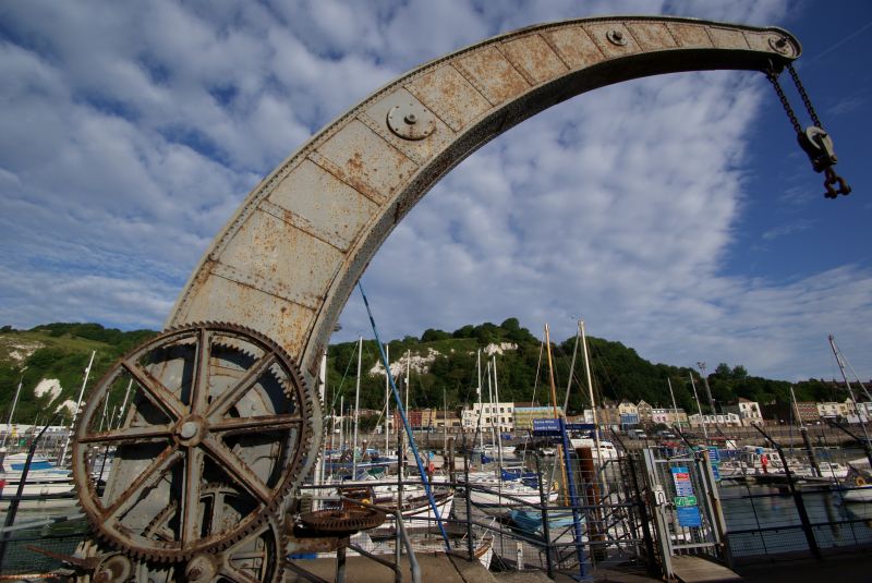
CRANE: The crane is a small hand-driven rotatory crane with swan-necked jib of riveted box frame construction. It was built by the Fairburn Engineering Co. of Manchester in 1868. It was once used by the Ordnance Department and was originally capable of lifting 50 tons. It was later de-rated to 20 tons and used for lifting yachts out of Wellington Dock.
HISTORY: Although visible fabric does not pre-date the early-C19, Wellington Dock follows the approximate outlines of part of the C16 harbour developments west of the town. The layout of the dock can be traced back to the early outline of the Great Pent built in the C16 as the replacement to the original first paradise devised by John Clerk in the early C16. The arrangement of docks and basins, now comprising the Wellington Dock, Granville Dock and Crosswall Quay, was originally arranged to take advantage of a shingle bar which formed a lagoon behind which the River Dour flowed. A large cross wall was built across the lagoon to form the Great Pent. This relates to the present Wellington Dock, from whose north end the River Dour flows. Water from the River Dour was then released through a sluice to clear the other half, or Great Paradise, of silt. The position of this crosswall is still present as Union Street, now containing a C20 swing bridge, replacing an earlier one of 1849 which was probably in or near the location of the original sluice.
The approximate outline of the present Wellington Dock as the Great Pent can be traced on a 1595 map of Dover Haven thought to be by Thomas Digges, the 1641 map from plat of Dover Castle Town and Harbour by William Eldred, View of Dover Harbour by J Bevan of 1684/5 and the Plan of the Town, Harbour and Fortifications of Dover of 1737 by H Fouquet. There was a proposal under the Civil Engineer W Moon to line the Pent in Portland stone but the only part which he completed before his death was the Pent Quay opposite Snargate Street, later known as Commercial Quay, which was constructed by 1832. Another quay at the Pent on the opposite side was completed by Fordham in 1833-4. The Pent, forerunner of Wellington Dock, is also shown on a 1834 plan by Thomas Telford accompanying plans for proposed works at the docks which recommended construction tunnels between the Wet Dock, Basin and Harbour. This plan shows both the new quays. Telford died the same year that the plan was produced but Wellington Dock was completed to the designs of the distinguished engineer James Walker, the second President of the Institute of Civil engineers, who inherited both Telford's presidency and commissions. The Great Pent was enclosed by stone quays and later renamed Wellington Dock after the Duke of Wellington, created Lord Warden of the Cinque Ports in 1829. A stone slipway called Cullins Slip is probably of early-C19 date. A Patent Slip was erected in 1849-50, capable of housing a vessel 230 feet long. This was lengthened in 1888 to take a vessel 556 feet long but it was built over for a car park in the late-C20.
On the 1866 Ordnance Survey map the area is still known as The Pent, with Slip Quay to the north west and Commercial Quay to the south west. A number of properties are shown along Slip Quay, probably connected with shipbuilding. By the 1898 map the name has changed to Wellington Basin and a number of cranes, mooring posts and bollards are marked. Between 1866 and 1898, Ballast Quay has been lengthened. There is little change by the 1907 and 1937 maps, but on the current map further quays are differentiated. Wellington Dock is currently in use as a marina.
SOURCES:
Oxford DNB articles on Thomas Telford and James Walker.
Alec Hasenson "The History of Dover Harbour". 1980. Passim.
Keith Parfitt and Barry Corke "Wellington Warehouses and Slipway, Dover". A Canterbury Archaeological Trust Report 1998/004.
Maritime Archaeology Ltd. Report "Dover Terminal 2 - Historic Environment Baseline Report." October 2008. P56-61.
English Heritage Unpublished report "Dover Harbour-Notes on Historical and Engineering Interest" September 2008.
REASONS FOR DESIGNATION:
Wellington Dock, Dover Harbour is designated at Grade II for the following principal reasons:
* Wellington Dock has historical interest because it occupies the approximate footprint of the Great Pent, shown on maps of Dover since 1595.
* The handsome ashlar walls with granite coping date from the early 1830s and were completed by 1844. James Walker, the distinguished maritime engineer who inherited Thomas Telford's unfinished commissions, is responsible for the post 1834 dock walls.
* Wellington Dock survives substantially intact.
* The crane at Esplanade Quay, Cullins slip and various cleats, bollards and mooring rings are reminders of Dover's shipbuilding and trading past.
* Wellington Dock is the part of Dover Harbour most closely linked to the town geographically, and a number of listed buildings are situated near the quays.
Wellington Dock, Dover Harbour is designated for the following principal reasons:
* Wellington Dock has historical interest because it occupies the approximate footprint of the Great Pent, shown on maps of Dover since 1595.
* The handsome ashlar walls with granite coping date from the early 1830s and the 1840s. The distinguished maritime engineer, James Walker, who inherited Thomas Telford's commissions after his death, is responsible for the post-1834 dock walls.
* Wellington Dock survives sustantially intact as a pre-1840 dock.
* The crane at Esplanade Quay, Cullins slip and various cleats, bollards and mooring rings are reminders of Dover's shipbuilding and trading past.
* Wellington Dock is the part of Dover Harbour most closely linked to the town and a number of listed properties are situated near its quays.
External links are from the relevant listing authority and, where applicable, Wikidata. Wikidata IDs may be related buildings as well as this specific building. If you want to add or update a link, you will need to do so by editing the Wikidata entry.


Other nearby listed buildings