Approximate Location Map
Large Map »
Latitude: 51.0645 / 51°3'52"N
Longitude: 1.0781 / 1°4'41"E
OS Eastings: 615771
OS Northings: 133970
OS Grid: TR157339
Mapcode National: GBR V0S.3F4
Mapcode Global: FRA F649.PTL
Plus Code: 9F33337H+Q6
Entry Name: Hythe Lifeboat Stations
Listing Date: 13 October 2010
Grade: II
Source: Historic England
Source ID: 1394324
English Heritage Legacy ID: 508819
ID on this website: 101394324
Location: Hythe, Folkestone and Hythe, Kent, CT21
County: Kent
District: Folkestone and Hythe
Civil Parish: Hythe
Built-Up Area: Hythe
Traditional County: Kent
Lieutenancy Area (Ceremonial County): Kent
Tagged with: Lifeboat station
HYTHE
687/0/10009 RANGE ROAD
13-OCT-10 Hythe Lifeboat Stations
II
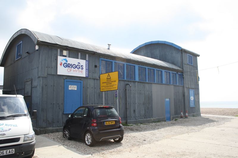
Two lifeboat stations. The northern lifeboat station was built in 1893 with a circa 1940 northern addition. The southern lifeboat station was built in 1934, probably supplied by the firm of Lewis and Lewis (later Lewis and Duvivier) of Haywards Heath.
NORTHERN LIFEBOAT STATION:
MATERIALS: Polychrome brick, mainly yellow with red brick dressings, cement bands and cement rendered north west gable. Welsh slate roof with terracotta ridge tiles.
PLAN: Rectangular lifeboat house of four bays with splayed northern addition divided into two rooms.
EXTERIOR: The north west end has a gable with moulded stone coping with kneelers and ball finial. Most of this front is now concealed beneath the c1940 yellow brick addition with flat concrete roof. The taller part of this has nearly full-height double doors facing west and two small square window openings facing north west, the lower part with a flat-arched entrance. The side elevations of the lifeboat station have moulded brick cornices, two cement bands and cambered brick window openings with wooden casement windows. The east side has a ledged and braced door. The south-east or seaward end has a gable with late-C20 brickwork but retains the original cement kneelers to the gable and sliding wooden doors below. The opening behind the wooden doors has been filled in by later C20 breezeblocks.
INTERIOR: The lifeboat house is divided into four bays with a wooden kingpost roof. The south eastern bay is floored and approached by a steep wooden ladder. The 1940 addition has a separate chamber.
SOUTHERN LIFEBOAT STATION:
MATERIALS: Steel framed on a concrete plinth, the walls and roof clad in corrugated iron and with a boarded wooden interior.
PLAN: Five bays with barrel-vaulted roof, the south-east bay of two storeys, the remainder of one storey.
EXTERIOR: The south-east or seaward elevation has a first-floor oriel window, probably of circa 1940. The original large doors for launching the lifeboat have been replaced by smaller late C20 doors. The side elevations have nine-light continuous casements. The north west or landward elevation has one window at the top and a ledged and braced pedestrian entrance.
INTERIOR: Exposed roof structure of steel trusses with wooden boarding above, the steel wall frame concealed by wooden boarding. The south-eastern bay has an upper room with concertina braces to the floor, approached up a steep wooden staircase. The first floor room has identical wooden boarding to the rest of the building but a late-C20 partition wall has been erected at the top of the stairs with late-C20 six-panelled door. The north-eastern side has a small office with boarded walls.
HISTORY: The original Royal National Lifeboat Institute (RNLI) lifeboat station at Hythe was established in 1876 on a site at the junction of Princes Parade and Seabrook Road. In 1891, as the result of the loss of the Benvenue in November 1891 it was decided to move to another site. The Seabrook Road lifeboat station was converted into a house and was demolished in 1956.
The 1893 Lifeboat House was built on a site adjacent to the Hythe and Sandgate Gas Company premises at the end of The Parade, Hythe. The existing lifeboat from Seabrook Road, the Meyer de Rothschild, was moved to the new lifeboat house. Three successive lifeboats were named The Meyer de Rothschild after the donor, as was customary. In 1929 the City of Nottingham came into service, a gift from Nottingham Lifeboat Fund. In 1934 a new larger lifeboat called The Viscountess Wakefield was donated by Viscount Wakefield, who lived in Hythe and was made a Freeman in 1930. Unfortunately the new lifeboat was too large for the existing lifeboat house so a new lifeboat house with a pre-fabricated steel frame, clad in corrugated iron and a barrel-shaped roof was constructed immediately to the south east of the 1893 lifeboat house in 1934.
In 1940 the coxswain of The Viscountess Wakefield, Henry (nicknamed Buller) Griggs, refused to take the vessel to Dunkirk for Operation Dynamo unless he could take his own crewmen who, he considered, knew the Channel waters better than any Royal Navy petty officers. The Royal Navy commandeered the vessel and it was the only lifeboat to be lost in the operation. 'Buller' Griggs and his brother Dick were dismissed from the lifeboat service three weeks after Dunkirk. During the Second World War the upper floor of the 1934 lifeboat station was used for spotting doodlebugs. Also during the war, a mine-watching post was built on the landward side of the 1893 lifeboat house as Hythe beach was mined to prevent an enemy landing.
After the War the lifeboat was not replaced. The 1893 lifeboat house was used for storage by the local scouts and the 1934 lifeboat house put to various uses, including a studio for Fred Cuming RA and later a boathouse and clubhouse for a diving group.
The 1893 lifeboat house is shown on the 1898 Ordnance Survey map with a rectangular shape. The 1934 lifeboat house is first shown on the 1938 Ordnance Survey map with an identical footprint to the present day.
SOURCES:
Kentish Express, April 17 1934, photograph and article about new lifeboat station.
Kentish Express, July 5 1940, report of dismissal of the coxswain and his brother from the Lifeboat Services.
Leach, Nicholas, For Those in Peril (1999, 251
Pearson, Geoff and Jarrett, Andy, Fishermans Beach Hythe, unpublished Heritage Statement of June 2010 by Better Places Ltd.
REASONS FOR DESIGNATION: The lifeboat stations are designated for the following principal reasons:
* Architectural interest: the 1893 Lifeboat Station is constructed of polychrome brickwork with slate roof and has a decorated end gable.
* Intactness: the 1893 Lifeboat Station is substantially intact except for the rebuilding of the seaward end gable and the loss of the landward doors. The 1934 Lifeboat Station survives substantially intact, except for the replacement of the casement window of the seaward gable end by an oriel window, probably to facilitate doodlebug spotting during WWII, and the loss of the seaward end doors.
* Rarity of Type: lifeboat stations are not numerous as a building type and although a number of steel-framed lifeboat houses with barrel-shaped roofs were erected by the RNLI in the early C20, the Hythe example is the only one with a two storey seaward end and may be the only surviving example not later extended.
* Historic interest: C19 and C20 Lifeboat stations are examples of early charitable and altruistic activity. Together these lifeboat stations provided sea rescue to this part of the south coast over a period of 47 years. They are probably the only surviving buildings in Hythe, one of the original Cinque Ports, demonstrating a maritime activity. The 1893 Lifeboat Station has an attached wartime extension, possibly connected with mine-watching. The 1934 Lifeboat Station was used for doodlebug spotting during WWII and it ceased to be used for sea rescue as a direct result of the Royal Navy beaching the lifeboat at Dunkirk, despite the warnings of the coxwain, 'Buller Griggs'.
* Group value: both lifeboat stations are within the sightlines of two scheduled Martello towers.
Listable at Grade II.
External links are from the relevant listing authority and, where applicable, Wikidata. Wikidata IDs may be related buildings as well as this specific building. If you want to add or update a link, you will need to do so by editing the Wikidata entry.


Other nearby listed buildings
