Approximate Location Map
Large Map »
Latitude: 51.3844 / 51°23'4"N
Longitude: -2.3632 / 2°21'47"W
OS Eastings: 374819
OS Northings: 165107
OS Grid: ST748651
Mapcode National: GBR 0QH.3BP
Mapcode Global: VH96M.0G0J
Plus Code: 9C3V9JMP+QP
Entry Name: 33, Gay Street
Listing Date: 12 June 1950
Last Amended: 15 October 2010
Grade: II
Source: Historic England
Source ID: 1395831
English Heritage Legacy ID: 511239
ID on this website: 101395831
Location: Bath, Bath and North East Somerset, Somerset, BA1
County: Bath and North East Somerset
Parish: Non Civil Parish
Built-Up Area: Bath
Traditional County: Somerset
Lieutenancy Area (Ceremonial County): Somerset
Church of England Parish: Bath St Michael Without
Church of England Diocese: Bath and Wells
Tagged with: Building
GAY STREET
(East side)
No.33 (Formerly Listed as: GAY
STREET
Nos.31-40 (Consec))
12/06/50
GV II
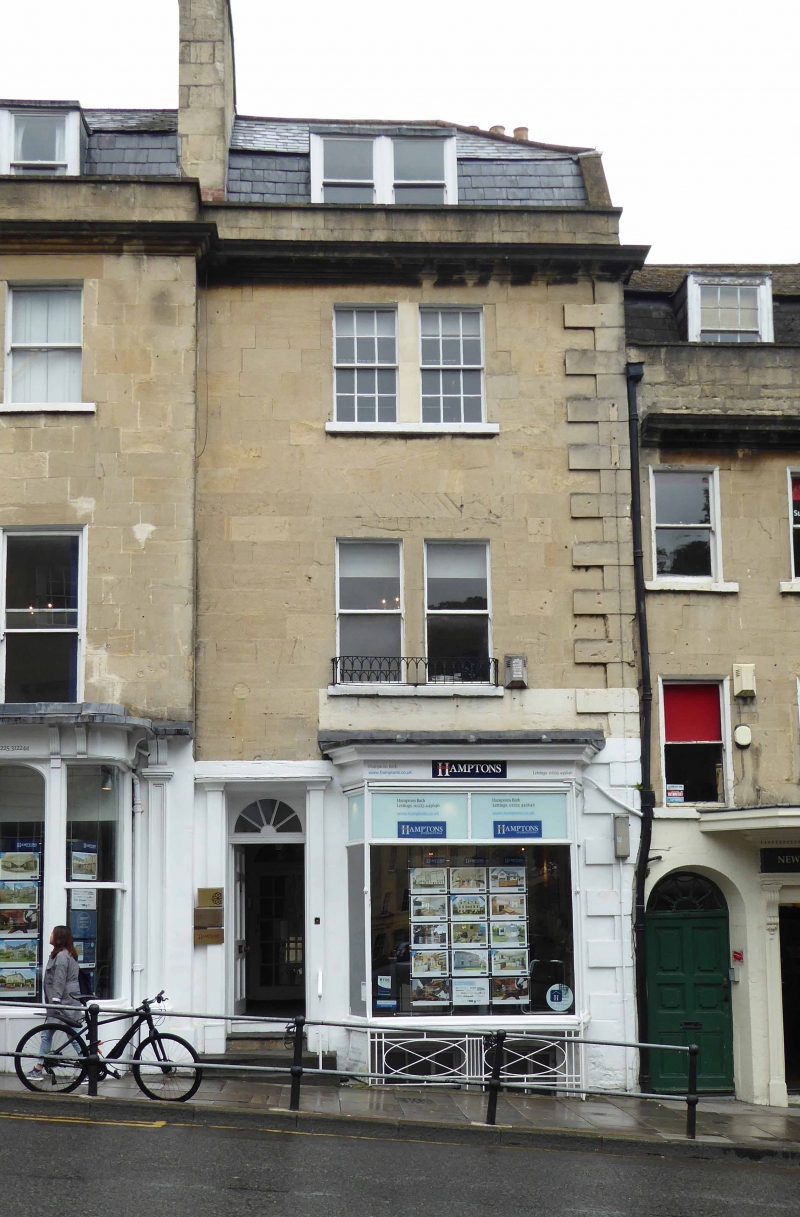
House, now shop with accommodation over. c1735-1740 with C20 alterations. By John Wood the Elder.
MATERIALS: Limestone ashlar, slate mansard roof with dormer. PLAN: Double depth plan.
EXTERIOR: Three storeys with attic and basement. Two-window range with roof half hipped to right with stack to rear, paired windows to upper floors, six/six-pane sashes to second floor and plate glass sashes to first floor, rusticated quoin to right, steps up to a set back six-panel door with reeded lintel and radial glazing bars to semicircular fanlight flanked by C20 pilasters and cornice. 1920-1930 shop window to right canted out and supported by railings to basement area that has paired three/six-pane sash windows. Paired flat-topped dormer with plain plate glass sashes. Rear elevation not seen.
INTERIOR: Not inspected.
HISTORY: Gay Street is named after Robert Gay, a surgeon of Hatton Garden and landowner of this area. Leases were granted a few months after the death of John Wood the Elder, in May 1754. The road forms a steeply rising link between Wood¿s two principal urban set-pieces. The southern part (now comprising Nos. 31-41 Gay Street) were originally known as Barton Street, and predated the remainder of the street by some twenty years. No. 33 is a part of an irregular terrace of three houses returned from George Street and developed in conjunction with Nos. 2-12 George Street (qv). The ground lease for the whole plot was taken by John Wood on 6th August 1733; the building leases were granted from 1734 on, and the Gay Street houses were inhabited and rated by 1740. This house looks as if it was probably one of the last built. This is the least cohesive and most altered stretch of Gay Street: hence its lower grade than the other sections.
SOURCES: (Mowbray Green, `The Eighteenth Century Architecture of Bath (1904), 140-143; Ison W: The Georgian Buildings of Bath: Bath: 1980: 130, 228; Finch G: Shopfront Record, Bath City Council: 1992).
Listing NGR: ST7481965107
External links are from the relevant listing authority and, where applicable, Wikidata. Wikidata IDs may be related buildings as well as this specific building. If you want to add or update a link, you will need to do so by editing the Wikidata entry.


Other nearby listed buildings
