Latitude: 50.2007 / 50°12'2"N
Longitude: -5.2411 / 5°14'27"W
OS Eastings: 168798
OS Northings: 38434
OS Grid: SW687384
Mapcode National: GBR Z3.GDBC
Mapcode Global: VH12R.37L0
Plus Code: 9C2P6Q25+7H
Entry Name: Hull at No.1 Loscombe Farm Cottages
Listing Date: 21 November 2011
Grade: II
Source: Historic England
Source ID: 1403691
ID on this website: 101403691
Location: Four Lanes, Cornwall, TR16
County: Cornwall
Civil Parish: Carn Brea
Built-Up Area: Four Lanes
Traditional County: Cornwall
Lieutenancy Area (Ceremonial County): Cornwall
Church of England Parish: Redruth
Church of England Diocese: Truro
Tagged with: Cottage
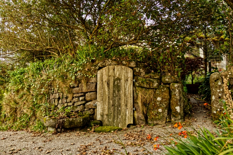
A hull or underground storage chamber that probably dates from the late C18 or early C19.
MATERIALS: granite; the subterranean parts have been cut into soft granite.
PLAN: above ground the hull takes the form of a rectangular-shaped mound which is aligned north-west to south-east. Below ground, it has an irregular plan consisting of a central passage and four side chambers.
EXTERIOR: the entrance mound has battered retaining walls of random stone rubble. The entrance itself is located on the south-west side and has a granite lintel over.
INTERIOR: from the entrance, a flight of eleven granite steps descend steeply to the floor of the hull; the walls to the stairs are of granite blocks and the roof consists of large granite lintels. Granite jambs, both with drill holes, and a lintel at the base of the steps mark the position of a former doorway. Beyond this, the central passage runs north-eastwards for approximately 10m; there are niches in the walls for candles. Leading off the passage, roughly at right angles, are four irregular side chambers and, at the far end of the hull, the passage widens out to form a fifth chamber. Inside, the chambers are both straight sided and irregularly curving in plan.
A hull (probably from huth for cover or shade) is an underground storage chamber or cave found in South West England, mainly in Cornwall. They are cut from a bed of soft granite known as growan or growder which lies immediately below the sub-soil. Hulls were usually built in close proximity to a building, sometimes being entered from within the dwelling house, and were generally built as stores or cellars for either domestic or for farm use. They maintained a constant temperature in winter and summer, and frost-free storage in winter, and were mainly used for the storage of root crops and other foodstuffs, though some are thought to have been for the storage of contraband wine and spirits during the C18 and C19.
The date of construction for the hull immediately to the south of Loscombe Farm Cottages is not known. It is not depicted on the tithe map of 1840, on the first edition Ordnance Survey map of 1880, or on the modern OS map. Its omission may be due to the fact that much of the structure is located underground and it may have thus been overlooked by the map surveyors. There were over twenty hulls recorded in the Four Lanes area at one time but now about five still remain. One source suggests that the example at No. 1 Loscombe Farm Cottages dates from the C18 although there is no documentary evidence to support this. This hull, located close to Loscombe Farm was probably used for storing dairy products.
The hull to the south of No. 1 Loscombe Farm Cottages in Four Lanes which probably dates from the late C18 or early C19 is designated at Grade II for the following principal reasons:
* Architectural interest: an unusually well-preserved example of a C18 or C19 storage facility, constructed on an ambitious scale;
* Rarity: as a regionally-distinctive type of structure, the hull is a relatively unusual survival of what was once a fairly common structure in parts of Cornwall.
External links are from the relevant listing authority and, where applicable, Wikidata. Wikidata IDs may be related buildings as well as this specific building. If you want to add or update a link, you will need to do so by editing the Wikidata entry.


Other nearby listed buildings