Approximate Location Map
Large Map »
Latitude: 50.1233 / 50°7'23"N
Longitude: -5.5463 / 5°32'46"W
OS Eastings: 146614
OS Northings: 30827
OS Grid: SW466308
Mapcode National: GBR DXPC.29Q
Mapcode Global: VH05H.T579
Plus Code: 9C2P4FF3+8F
Entry Name: Boundary Stone 47m North-West of the Fire Station
Listing Date: 23 February 2012
Grade: II
Source: Historic England
Source ID: 1408102
ID on this website: 101408102
Location: Heamoor, Cornwall, TR18
County: Cornwall
Civil Parish: Penzance
Built-Up Area: Penzance
Traditional County: Cornwall
Lieutenancy Area (Ceremonial County): Cornwall
Church of England Parish: Madron
Church of England Diocese: Truro
Tagged with: Boundary marker
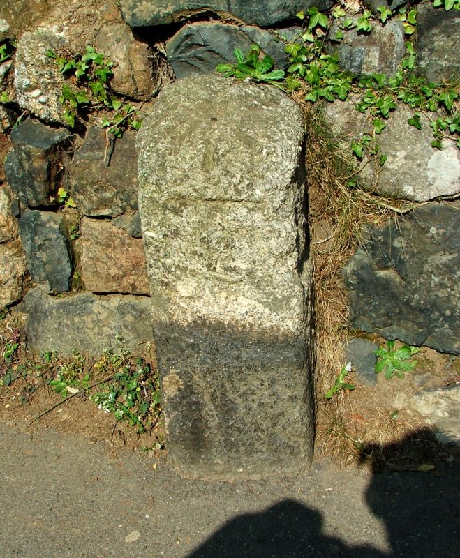
A C17 boundary stone marking the former boundary of the Borough of Penzance. One of a pair that survive from an original group of four.
The boundary stone is set within a stone wall, at the rear of the footpath on the east side of St Clare Street. It is constructed of granite, rectangular on plan with a rounded top. The stone is 64cm tall. There are rectangular recesses on three faces, where the stone has been cut back to leave a raised inscription, which reads: P 16 87. The lettering is rounded and worn. There is a broad bench mark at the top of the front face and a metal pin in the top.
James I granted a charter for the Borough of Penzance in 1614, and four inscribed stones were erected in 1687 to determine where the boundary was crossed by the main roads into the Borough. These were located at Chyandour, Chapel St Clare, Alverton and Wherrytown, costing £1 19s 6d to make and £1 10s 0d to erect. As late as the mid-C19 the stones were used as markers for a traditional race carried out by Penzance councillors called "beating the bounds".
One of the stones was removed when Alverton Road was widened, and a memorial plaque was erected nearby in 1867. The stone in Wherrytown is thought to have been removed during the development of the Esplanade. The stones at Chyandour and Chapel St Clare remain in situ.
The boundary stone 47m north-west of the fire station, Nancealverne, Penzance, Cornwall is designated at Grade II, for the following principal reasons:
* Intactness: it is a good example of a C17 borough boundary stone;
* Historic interest: it illustrates the establishment of local government in this part of Cornwall;
* Group value: it has strong group value with the other surviving boundary stone.
External links are from the relevant listing authority and, where applicable, Wikidata. Wikidata IDs may be related buildings as well as this specific building. If you want to add or update a link, you will need to do so by editing the Wikidata entry.


Other nearby listed buildings
