Approximate Location Map
Large Map »
Latitude: 51.5085 / 51°30'30"N
Longitude: -0.0825 / 0°4'56"W
OS Eastings: 533171
OS Northings: 180580
OS Grid: TQ331805
Mapcode National: GBR TF.MF
Mapcode Global: VHGR0.JB8Y
Plus Code: 9C3XGW59+92
Entry Name: River Wall, Stairs and Cranes, Custom House Quay
Listing Date: 2 October 2014
Grade: II*
Source: Historic England
Source ID: 1419872
ID on this website: 101419872
Location: The Borough, City of London, London, EC3R
County: London
District: City and County of the City of London
Electoral Ward/Division: Billingsgate
Parish: Non Civil Parish
Built-Up Area: City of London
Traditional County: Middlesex
Lieutenancy Area (Ceremonial County): City of London
Church of England Parish: All Hallows-by-the-Tower
Church of England Diocese: London
Tagged with: Wall
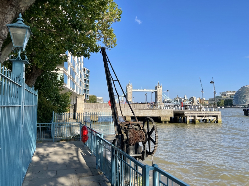
River wall, stairs and two cranes. Built 1817-19 for the Board of the Commissioners of Customs to the designs of John Rennie. Jolliffe and Banks contractors. The eastern crane is of the 1820s or 30s, and may have been installed here c1828; the western crane is probably a later addition of the 1830s. The manufacturers are unknown.
River wall, stairs and two cranes. Built 1817-19 for the Board of the Commissioners of Customs to the designs of John Rennie. Jolliffe and Banks contractors. The eastern crane is of the 1820s or 30s, and may have been installed here c1828; the western crane is probably a later addition of the 1830s. The manufacturers are unknown.
The quay wall runs east-west along the river frontage of Custom House and is approximately 170m long, terminating at the east beneath Sugar Quay jetty. It is curved in section, built in rusticated granite with diminishing courses towards the centre of the curve. The coping slabs are inset with diamond slips. There are vertical recesses in the masonry for timber fenders, all but one of which remain in situ; these are of indeterminate date. The wall breaks forward at the east end, followed by a recess for the stairs which run in a straight flight parallel to the wall, with two intermediate landings. The stairs are enclosed by a ramped wall with slightly rounded copings; the steel handrails* are modern and not of special interest. To either side of the stair recess is an arched niche. Incised letting on the wall’s top masonry course beneath the coping reads: ‘A .B / 1819’ and ‘ST. D.E / 1819’ at the east end, and ‘ST. D.E / 1819’ and ‘ST. / M. AT H / 1819’ near the west end, denoting (from east to west) the three City parish boundaries traversed by the wall: All Hallows Barking, St Dunstan-in-the-East and St Mary-at-Hill.
The eastern crane, which stands just behind the coping, is of a type that began to emerge in the 1810s when cast iron was being applied to free-standing wharf cranes, representing an evolution from traditional timber models. It stands on a fluted cast-iron column on a circular base. The jib comprises two cast-iron frames, each a single casting of a truss-like form, mounted either side of a cast-iron pintle; the chords and integral St Andrew’s Cross bracing are I section. This sole use of cast iron was to be largely superseded by composite construction of cast and wrought-iron members where strong but light structures were required, as in this instance, and as illustrated by the western crane. The western crane, which is fixed to the wall coping, is of a typologically later design. It stands on a sturdy tapering cast-iron column within a cast-iron frame which carries the pintle. The lower part of the jib comprises a single cast-iron cruciform strut ending in a tubular section bearing on the base, and the upper part a pair of wrought-iron tensile tie-rods attached to the frame. The brake-wheel has been broken, but the crane is otherwise intact. The diagonal cross-shaped iron strapping set into the coping, centred on the post, appears to be a means of cramping the stones for greater strength when the crane was installed. The pair constitute rare and early examples of iron cranes.
The late-C19 iron railings at the east and west ends of the wall, and C20 steel balustrade which runs the length of the wall behind the coping, are not of special interest*.
* Pursuant to s.1 (5A) of the Planning (Listed Buildings and Conservation Areas) Act 1990 (‘the Act’) it is declared that these aforementioned features are not of special architectural or historic interest.
The Custom House was established at Wool Quay in the C14 and successively rebuilt and enlarged over the course of five centuries. Wren’s Custom House of 1669-71, which replaced a C16 building destroyed in the Fire, was itself burned down in 1715. Its successor of 1718-25 by Thomas Ripley would before long prove inadequate to accommodate the huge expansion of business generated by London’s trade growth in the latter half of the C18, and the opening of the first enclosed commercial wet docks in the first decade of the C19. In 1809, the Board of Commissioners of Customs obtained parliamentary consent for larger premises and the new Custom House, designed by David Laing, was built in 1813-17 on a site just to the west of its predecessor.
The construction of the quay wall was among a series of commissions for docks and wharves on the Thames undertaken after the end of the Napoleonic wars by the eminent civil engineer John Rennie (1761-1821) with Jolliffe and Banks, a prominent firm of civil engineering contractors. The firm had worked under Rennie for over two decades on several major projects in London, including Waterloo Bridge (1811-17), Southwark Bridge (1815-19); the entrance to London Docks and the river wall at Deptford Dockyard and Victualling Yards (1816-19), employing state-of-the art techniques including cofferdams and steam pumping engines. Although theirs was not the lowest tender Rennie recommended them because they had ‘all the required materials in hand’ as well as pile engines and other machinery (presumably from work on Southwark Bridge) ‘and from their great experience in works of this sort there is the best assurance of its being well and speedily executed’. The firm built at the same time the adjacent wall to Billingsgate Dock to the west, which was demolished c1872 when the basin was infilled to make way for the new Billingsgate Market.
The cranes at the wall’s eastern end appear to have been present at Custom House Quay from an early stage. The eastern crane is not in situ and stood further west along the quay wall from c1957 until the 1990s. Its construction is consistent with an 1820s or 30s date, and it is very likely to be the same crane that stood in front of the Custom House portico, presumably for lifting goods in and out of the basement, which last appears in that position on the 1952 OS map. A similar crane is depicted in engravings from 1828 onwards, and in late-C19 photographs, and may have been installed on the completion of the 1825-8 rebuilding of the central block of Custom House under Robert Smirke. The western crane is in situ; a similar if not identical crane is depicted in engravings of the late 1830s onwards, and in late-C19 photographs. Its construction is consistent with an 1830s date.
The river wall, stairs and cranes, Custom House Quay, are listed at Grade II* for the following principal reasons:
* Architectural interest: an impressive and virtually intact structure designed by the great engineer John Rennie, little of whose work in London has survived;
* Historic interest: as the quay serving the Custom House, where detained goods were loaded for storage;
* Technological interest and rarity: the two iron cranes are early and well-preserved examples of their type, illustrating the early-mid C19 transition from cast-iron to composite cast and wrought-iron construction; that they remain in their historic location compounds their significance;
* Group value: with the Grade I listed Custom House; the ensemble as a whole constituting an outstanding survival of London’s late-Georgian riverscape.
External links are from the relevant listing authority and, where applicable, Wikidata. Wikidata IDs may be related buildings as well as this specific building. If you want to add or update a link, you will need to do so by editing the Wikidata entry.


Other nearby listed buildings
