Approximate Location Map
Large Map »
Latitude: 50.7663 / 50°45'58"N
Longitude: -1.2769 / 1°16'36"W
OS Eastings: 451090
OS Northings: 96551
OS Grid: SZ510965
Mapcode National: GBR 89L.VBW
Mapcode Global: FRA 8762.4C7
Plus Code: 9C2WQP8F+G6
Entry Name: Bathing House and a 50m length of raised sea wall at Norris Castle
Listing Date: 16 November 2016
Grade: II
Source: Historic England
Source ID: 1438948
ID on this website: 101438948
Location: Isle of Wight, PO32
County: Isle of Wight
Civil Parish: East Cowes
Built-Up Area: East Cowes
Lieutenancy Area (Ceremonial County): Isle of Wight
Church of England Parish: East Cowest St James
Church of England Diocese: Portsmouth
Tagged with: Architectural structure
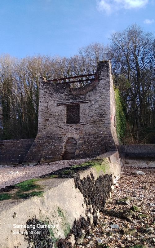
Lodge and bath house with attached raised sea wall, early C19, for Lord Henry Seymour.
Lodge and bath house with attached raised sea wall, early C19, for Lord Henry Seymour.
MATERIALS: constructed of coursed rubble and squared Bembridge limestone, with later repairs in red brick and concrete. Attached sea wall of squared and coursed quarry-faced stone.
PLAN: a two-storey square tower with a single-cell plan. It is built into the sea wall so that access from the estate is on the first floor, with an internal staircase providing access down to beach level. The sea wall extends eastwards from the north-east corner of the building.
EXTERIOR: the Bathing House is currently a roofless shell (2016). The lower storey of the north elevation, facing the sea, is battered out. There is a blocked round-headed doorway with stone voussoirs and a chamfered outer edge to the ground floor, and a square-headed opening to the first floor. The east front includes the main entrance; a chamfered round-headed doorway, and above it, an oculus. At the west end of the south elevation is an inserted square-headed doorway with red-brick jambs and a concrete lintel. Above the doorway is the scar of a lean-to roof for a single-storey addition, which extended to the south with the estate boundary wall forming its west wall. The west elevation meets the East Cowes Esplanade and has a single squared-headed opening with a stone cill at first floor level.
The sea wall is built of squared and coursed quarry-faced stone with a battered outer edge. A 50m length survives to full height, extending east from the Bathing House. Thereafter the wall is ruinous, having suffered erosion, landslips and storm damage, and varies in height with some sections missing altogether; this section, beyond the 50m length, is therefore excluded from the listing.
INTERIOR: a stone staircase in the south-east corner leads down to the ground floor, above which are springings of a brick barrel-vault. An alcove with a red-brick segmental arch is built into the east wall. At first floor level there are fragments of plaster on the walls, tooled to imitate ashlar stonework. There are repairs in red brick and concrete whilst two steel I-beams support the tops of the walls.
The Bathing House, as it is now known, and attached sea wall are situated at the north-west corner of Norris Castle estate. It is located at Old Castle Point, near the original site of East Cowes Castle, an artillery fort built by Henry VIII in 1539-42, which was ruinous by the C17. In 1795 Lord Henry Seymour (1746-1830) purchased a small farm called ‘Norris’ and subsequently constructed a marine villa estate. It included Norris Castle, a Gothic Revival house built in the form of a castle, and a castellated model farm (Norris Castle Farm) constructed to the designs of the architect James Wyatt (1746-1813) from c1799 (both Grade I listed). A landscaped park with an oval loop of carriage drive was created from former fields covering 124 acres and is shown on the 1810 OS map (Grade I registered). The inclusion of a watercolour view of Norris by the landscape designer Humphry Repton (1752-1818) in the 1805 edition of Peacock's Polite Repository suggests his likely involvement in the design (Carter et al 1982).
The Bathing House was built in the early C19 as part of the landscaped park. It is not shown on the small scale (one inch to one mile) 1810 OS map but is first recorded in a sketch by Captain Thomas Hastings (1778-1854) dated October 1825. The sketch shows a square tower with round-headed doorways, oculi in the north and east elevations, a crenelated parapet and flagstaff. The building may initially have served as a lodge before subsequently being used as a bathing house; a ‘Keeper’s Lodge’ of similar description was designed by Humphry Repton at Hooton Park, Cheshire, in c.1802 and included a ‘prospect room’ and hot and cold baths (Phibbs 2016, 25). At Norris, the attached sea wall formed the north coastal boundary of the estate, eventually extending nearly a mile to the east to the boundary with Osborne House. A landing quay was situated at the east end of the wall and may have been used by visitors or tradesmen bringing goods over from the mainland. Letters written in the 1820s attest to the construction of the sea wall at a cost of £24,000 (Ettwein Bridges Architects 2016, 23, 65). The Norris Castle landscape was laid out according to picturesque principles and the Bathing House was designed as a castellated tower in a similar style to the battlemented Castle and model farm. Together with the raised sea wall, it formed a formal foreground to the view of the Castle from the Solent. The sea wall was used a terrace walk, and possibly a carriage drive, and the Bathing House may have served as a recreational stopping point on a route around the landscape.
A set of 1830 sales particulars describe the Bathing House as: ‘A Bath House, for Hot and Cold Sea Bathing... ... At the Western Extremity of the Estate, contiguous to the Beach, A Castellated Square Tower, with a Porch, leading to a Sitting Room; Bath Room, with Plunging Bath, for Hot and Cold Sea Bathing, Kitchen; Pump, drawing Sea Water; and Coal Hole; Stairs to the Water’s Edge, with landing from whence there are Beautiful views of Cowes &c.’ (Phibbs 2016, 15). The sea wall is described as: ‘A Grand and Delightful Terrace Walk, nearly a mile in length, Embanked, at a very considerable Expense, in a most substantial manner; near to which, Vessels of considerable Burden may lay.’
Norris Castle hosted numerous royal visits during the C19, including by George IV (whilst Prince Regent), the Duchess of Kent, Queen Victoria and Kaiser Wilhelm. During one visit in 1852, Queen Victoria completed a pen and ink drawing of the Bathing House, showing the crenelated tower with slipway and a single storey gabled section extending northwards. The Bathing House is shown on the 1845 Tithe map and is labelled as ‘Bathing Ho.’ on the 1864 OS map. The 1898 OS map shows it within a small rectangular fenced enclosure and on a 1916 estate plan it is labelled ‘Bathing House and Boat House’ (Ettwein Bridges Architects 2016, Appendix A). It subsequently became derelict and roofless, probably during the later C20 when the sea wall suffered erosion, landslips and storm damage; only a 50m length of the sea wall, extending from the north-east corner of The Bathing House, remains largely intact, thereafter it is currently ruinous (2016).
The Bathing House and attached 50m length of raised sea wall, built in the early C19 for Lord Henry Seymour, is listed at Grade II for the following principal reasons:
* Historic interest: as an important component of a designed landscape laid out according to picturesque principles; the sea wall was used a terrace walk, and possibly a carriage drive, and the Bathing House was used for bathing and probably served as a recreational stopping point on a route around the landscape;
* Rarity: as a relatively rare surviving example of a C19 bath house within a landscaped villa estate, forming a key element of the commanding view of Norris Castle, in its setting, from the sea;
* Materials: the Bathing House and sea wall are finely constructed of coursed or squared quarry-faced stone, with an outer batter facing the Solent;
* Historic association: as part of an estate regularly visited by the royal family in the C19, and a building sketched by Queen Victoria in 1852;
* Group value; as part of a marine villa estate of outstanding architectural and historic interest, including a Grade I listed house and model farm, Grade II listed lodges, Pump House, two cattle shelters and four stone-lined watering ponds, within a Grade I registered landscape, adjacent to a Grade II* registered park and Grade I listed house at Osborne.
External links are from the relevant listing authority and, where applicable, Wikidata. Wikidata IDs may be related buildings as well as this specific building. If you want to add or update a link, you will need to do so by editing the Wikidata entry.


Other nearby listed buildings
