Approximate Location Map
Large Map »
Latitude: 51.7758 / 51°46'32"N
Longitude: -1.2374 / 1°14'14"W
OS Eastings: 452713
OS Northings: 208845
OS Grid: SP527088
Mapcode National: GBR 8YS.L07
Mapcode Global: VHCXN.HMQJ
Plus Code: 9C3WQQG7+83
Entry Name: Old Marston War Memorial
Listing Date: 20 January 2017
Grade: II
Source: Historic England
Source ID: 1441014
ID on this website: 101441014
Location: St Nicholas's Church, Marston, Oxford, Oxfordshire, OX3
County: Oxfordshire
District: Oxford
Civil Parish: Old Marston
Built-Up Area: Oxford
Traditional County: Oxfordshire
Lieutenancy Area (Ceremonial County): Oxfordshire
Church of England Parish: Marston
Church of England Diocese: Oxford
Tagged with: War memorial
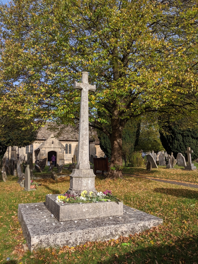
First World War memorial.
MATERIALS: limestone.
DESCRIPTION: the memorial is located in a prominent position to the left of the path leading to St Nicholas’s Church. It consists of a corniced stone cross with a quatrefoil motif on the front (south-facing) side. Its tapering shaft is octagonal with carved broach stops at the base. It is set on an octagonal plinth on a square chamfered stone with carved broach stops. This in turn stands on a two-stepped square base. The total height of the memorial is approximately 2.75 metres.
On the three faces of the front of the octagonal base, in capitals: 1914 / LEST / WE / FORGET / 1918. On the riser of the top step is inscribed: THEIR NAMES ARE RECORDED WITHIN THE CHURCH.
This List entry has been amended to add the source for War Memorials Online. This source was not used in the compilation of this List entry but is added here as a guide for further reading, 28 July 2017.
The aftermath of the First World War saw the biggest single wave of public commemoration ever with tens of thousands of memorials erected across England, both as a result of the huge impact the loss of three quarters of a million British lives had on communities and the official policy of not repatriating the dead, which meant that the memorials provided the main focus of the grief felt at this great loss.
One such memorial was raised at St Nicholas’s Church, Old Marston (then just outside the city of Oxford) as a permanent testament to the sacrifice made by the members of the local community who lost their lives in the First World War.
This war memorial contains no names. The date of the memorial is uncertain. There is no mention of it in a newspaper report of December 1919 about the unveiling of the related memorial plaque with names inside the church, and this probably indicates that it dates from the 1920s.
Old Marston War Memorial is listed at Grade II for the following principal reasons:
* Historic interest: as an eloquent witness to the tragic impact of world events on this community, and the sacrifices it has made in the conflicts of the C20;
* Architectural interest: an elegant and striking memorial cross;
* Group value: with the Church of St Nicholas (Grade I) and graves within the churchyard (Grade II).
External links are from the relevant listing authority and, where applicable, Wikidata. Wikidata IDs may be related buildings as well as this specific building. If you want to add or update a link, you will need to do so by editing the Wikidata entry.


Other nearby listed buildings
