Approximate Location Map
Large Map »
Latitude: 51.4319 / 51°25'54"N
Longitude: -0.1152 / 0°6'54"W
OS Eastings: 531115
OS Northings: 172008
OS Grid: TQ311720
Mapcode National: GBR FY.KMG
Mapcode Global: VHGRC.Y8FM
Plus Code: 9C3XCVJM+QW
Entry Name: War Memorial at St Peter's Church, Streatham
Listing Date: 20 March 2017
Grade: II
Source: Historic England
Source ID: 1441847
ID on this website: 101441847
Location: St Peter's Church, Streatham, Lambeth, London, SW16
County: London
District: Lambeth
Electoral Ward/Division: Streatham Wells
Parish: Non Civil Parish
Built-Up Area: Lambeth
Traditional County: Surrey
Lieutenancy Area (Ceremonial County): Greater London
Church of England Parish: Streatham St Peter
Church of England Diocese: Southwark
Tagged with: War memorial
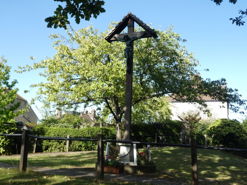
First World War memorial, unveiled 1922.
The memorial stands in the grounds of St Peter's Church, Streatham and comprises a Calvary cross with a bronze depiction of the crucifixion and bronze INRI scroll. The Calvary rises from a tall wooden shaft, set on a pentagonal stone plinth.
The front face of the plinth bears the inscription THIS MEMORIAL / WAS ERECTED 1921 / IN GRATEFUL MEMORY OF / THE MEMBERS OF THIS / PARISH AND CONGREGATION / WHO GAVE THEIR LIVES / FOR THEIR COUNTRY / IN THE WAR 1914-1918 / MAY THEY REST IN PEACE the other four faces bear the names of the Fallen. The whole stands on stone paving slabs in the shape of a pentagon, surrounded by small hedges and wooden posts supporting a rope, all set on a circular brick podium.
This List entry has been amended to add the source for War Memorials Online. This source was not used in the compilation of this List entry but is added here as a guide for further reading, 21 March 2017.
The aftermath of the First World War saw the biggest single wave of public commemoration ever with tens of thousands of memorials erected across England. This was the result of both the huge impact on communities of the loss of three quarters of a million British lives, and also the official policy of not repatriating the dead, which meant that the memorials provided the main focus of the grief felt at this great loss.
One such memorial was raised at St Peter's Church in Streatham as a permanent testament to the sacrifice made by the members of the local community who lost their lives in the First World War. The memorial was unveiled on 15 January 1922.
The war memorial at St Peter's Church, Streatham is listed at Grade II for the following principal reasons:
* Historic interest: as an eloquent witness to the tragic impact of world events on this local community, and the sacrifice it has made in the First World War;
* Design: a well-executed and imposing Calvary cross;
* Group value: with the Grade II*-listed St Peter's Church.
External links are from the relevant listing authority and, where applicable, Wikidata. Wikidata IDs may be related buildings as well as this specific building. If you want to add or update a link, you will need to do so by editing the Wikidata entry.


Other nearby listed buildings
