Approximate Location Map
Large Map »
Latitude: 54.4017 / 54°24'6"N
Longitude: -1.74 / 1°44'24"W
OS Eastings: 416975
OS Northings: 500726
OS Grid: NZ169007
Mapcode National: GBR JK9J.2W
Mapcode Global: WHC6D.7MPF
Plus Code: 9C6WC725+MX
Entry Name: Wall incorporating C18 water supply point and a circa 1800 lamp standard
Listing Date: 3 July 2020
Grade: II
Source: Historic England
Source ID: 1463907
ID on this website: 101463907
Location: Richmond, North Yorkshire, DL10
County: North Yorkshire
District: Richmondshire
Civil Parish: Richmond
Built-Up Area: Richmond
Traditional County: Yorkshire
Lieutenancy Area (Ceremonial County): North Yorkshire
Tagged with: Wall
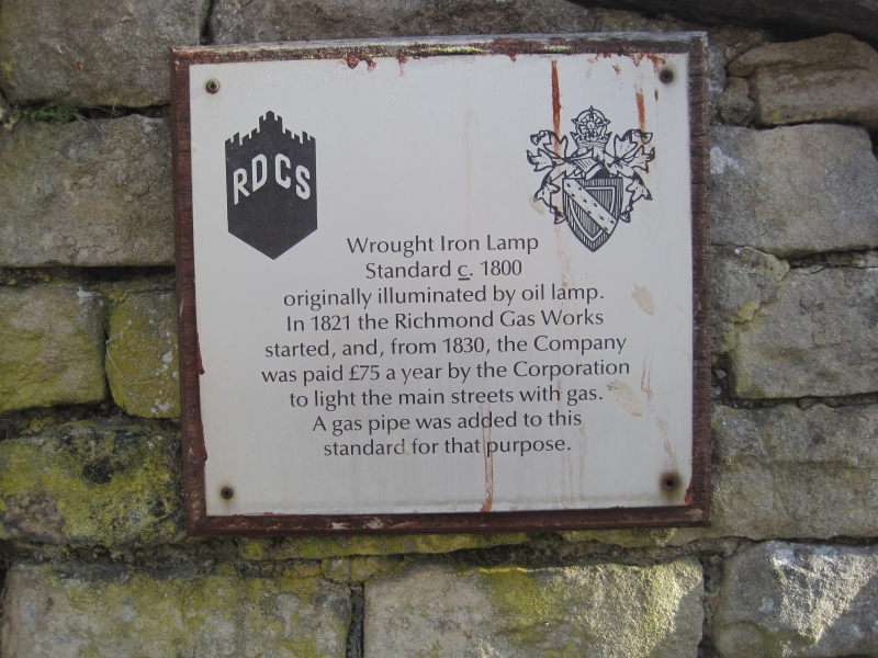
Wall incorporating a former public water supply point established circa 1782 with an associated oil lamp standard erected circa 1800 and converted to coal gas in 1830.
Wall incorporating a former public water supply of circa 1782 and a street lamp of circa 1800.
MATERIALS: walling of local limestone with a dressed stone pilaster and coping. Lamp standard of wrought iron.
DESCRIPTION: the wall is of roughly coursed rubble to the east face and well-coursed, squared stone to the west. The wall top follows the slope of the hill with a horizontal step around midway. This is marked on the west face with a monolithic pilaster with a simple base and cornice above which rises the lamp standard that is fixed to the wall coping. Towards the base of the pilaster there are marks left for the fittings associated with the water supply, including a blocked hole that formerly held the water pipe. Below this is an inscribed Ordnance Survey bench mark.
The wrought iron lamp standard is in the form of a vertical bar supported on four sides with relatively simple, but decorative scrolled ironwork. The lantern has been lost, but the lantern base plate, a projecting ladder rest and a section of gas pipe all remain in situ.
In 1771 Richmond’s market cross was replaced with a large obelisk built over a 12,000 gallon water cistern, this cistern forming part of the town’s public water supply. About a decade later, around 1782, a water supply outlet from this cistern was created at the junction between Bargate and Cornforth. It is thought that around 1800 this site was provided with an oil lamp set on a standard which was then converted to coal gas in 1830, following the establishment of the Richmond Gas Works in 1821. The wall that incorporates the water supply point and lamp standard is depicted on the first edition 1:10560 Ordnance Survey map surveyed in 1854, but does not mark the lamp or water supply because of the scale of the map. The 1:500 Town Plan surveyed 1891-1892 does mark the water supply, depicting a water trough projecting west from the wall, identified W.T. The lamp, marked as L, is shown at the southern end of the wall indicating that it was repositioned about 4m northwards to its current location, probably after its use for street lighting ended. It is not known when the lamp and water supply were decommissioned.
The wall with the C18 water supply point and the circa 1800 lamp standard are listed Grade II for the following principal reasons:
Historic interest:
* as early, rare surviving examples of street furniture, demonstrating C18 provision of drinking water and that Richmond was one of the earliest towns in the country to have street lighting.
Architectural interest:
* for the design interest of using a classical-style pilaster for the water supply point and scrolled wrought iron for the lamp standard.
Group value:
* with the surrounding listed buildings and the adjacent listed cobbled street surfacing;
* the water supply point has historical functional group value with the listed obelisk in Richmond’s Market Place which overlies the cistern which was the source of the water supply.
External links are from the relevant listing authority and, where applicable, Wikidata. Wikidata IDs may be related buildings as well as this specific building. If you want to add or update a link, you will need to do so by editing the Wikidata entry.


Other nearby listed buildings