Approximate Location Map
Large Map »
Latitude: 53.4583 / 53°27'29"N
Longitude: -2.5335 / 2°32'0"W
OS Eastings: 364673
OS Northings: 395863
OS Grid: SJ646958
Mapcode National: GBR BXRG.90
Mapcode Global: WH98D.1BVM
Plus Code: 9C5VFF58+8J
Entry Name: Parish Boundary Stone, Broseley Lane
Listing Date: 16 August 2019
Grade: II
Source: Historic England
Source ID: 1464173
ID on this website: 101464173
Location: Leigh Golf Course, Twiss Green, Warrington, Cheshire, WA3
County: Warrington
Civil Parish: Culcheth and Glazebury
Built-Up Area: Culcheth
Traditional County: Lancashire
Lieutenancy Area (Ceremonial County): Cheshire
Tagged with: Boundary marker
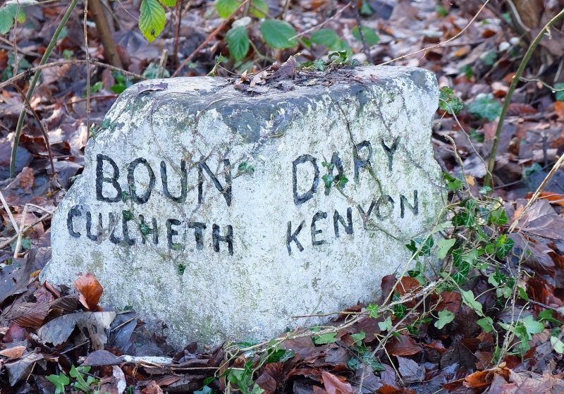
Boundary Stone, early C19 or earlier.
Boundary Stone, early C19 or earlier.
MATERIALS: sandstone, painted.
DESCRIPTION: the boundary stone is set on the west verge of Broseley Lane. It has a similar appearance to a small milestone, standing approximately 0.35m high, with a triangular section and a flat top. The latter is inscribed with a non-vertical bench mark symbol. The rear panel is plain, the southern panel is inscribed: BOUN/ CULCHETH and the northern panel is inscribed DARY/ KENYON; the inscription BOUN and DARY forming the word: BOUNDARY. The stone is painted white and all lettering is black.
The boundary stone is considered to be at least early C19 in date, and to mark the parish boundary between Kenyon and Culcheth, which followed the course of the now culverted Jibcroft Brook. It is depicted on the first edition 1:10,560 Ordnance Survey map, surveyed between 1845 and 1847, and continues to be shown on later editions in the same position as today. The parish boundary was originally marked along its length by a number of boundary stones and posts, of which at least one other is known to survive, situated in a wall adjacent to Boundary Cottages, Wigshaw Lane. The boundary stone was also used as an Ordnance Survey bench mark and is depicted as such on the 1893 1:2,500 Ordnance Survey map. The stone has suffered some minor damage from mowing machines.
The Parish Boundary Stone, Broseley Lane, Culcheth, is listed at Grade II for the following principal reasons:
Architectural Interest:
* it dates to the early C19 or earlier and there is a general presumption that all surviving pre-1850 parish boundary stones should be listed;
* it survives intact in its original position, with a legible inscription, and includes a non-vertical bench mark that adds to its special interest.
Historic Interest:
* the stone is a tangible reminder of the delineation of the limits of parochial jurisdiction during the early C19.
External links are from the relevant listing authority and, where applicable, Wikidata. Wikidata IDs may be related buildings as well as this specific building. If you want to add or update a link, you will need to do so by editing the Wikidata entry.


Other nearby listed buildings