Approximate Location Map
Large Map »
Latitude: 53.4419 / 53°26'30"N
Longitude: -1.4684 / 1°28'6"W
OS Eastings: 435405
OS Northings: 394031
OS Grid: SK354940
Mapcode National: GBR LX5M.WX
Mapcode Global: WHDD9.DRZ8
Plus Code: 9C5WCGRJ+PJ
Entry Name: Former cruck barn attached to the south of 35 St Mary's Lane, Ecclesfield
Listing Date: 1 November 2021
Grade: II
Source: Historic England
Source ID: 1478494
ID on this website: 101478494
Location: Ecclesfield, Sheffield, South Yorkshire, S35
County: Sheffield
Civil Parish: Ecclesfield
Built-Up Area: Sheffield
Traditional County: Yorkshire
Lieutenancy Area (Ceremonial County): South Yorkshire
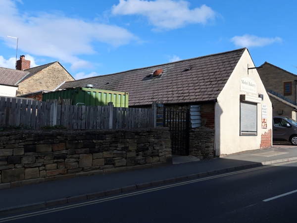
A cruck-framed, stone-built former barn of pre-1700 date with possible medieval origins, and with later alterations.
A former barn, used as a cafe in 2021, of pre-1700 date but possibly of medieval origins, with C20 and C21 alterations.
MATERIALS: stone walling, slate roofs, timber cruck frames and purlins.
PLAN: the barn is aligned roughly north-south, forming the single-storey south end of a linear range; the two-storey north end (not included in the listing) comprises the former farmhouse, now numbered 35 and 37.
EXTERIOR: the south wall (approximately 6m wide) is rendered over brick laid in English Garden Wall bond, and has a C20 square shop window.
The east front (approximately 16m long) is largely of roughly-squared stone laid to irregular courses, with some irregular door jambs of brick. At the left a doorway is blocked in brick, with an inserted window. To the right is a stone-blocked former window, with, reading to the right, a small window, double doorway, two single doorways, a square window and a large double doorway with sliding metal doors. The end of three timber tie-beams are exposed, delineating four bays to the building. Bays 1 and 2 (from the left) are roofed with heather slate, bays 3 and 4 blue slate, with numerous roof vents.
At the south end the west wall has a metre-high linear buttress around 10m long and half a metre wide. Above this the walling is random-coursed and patched with mortar, with one exposed tie-beam end; at the north end of the buttress is a doorway with modern door. To the north the walling is more regular with only one small vent opening. At the left the wall is abutted by an extension (not included in the listing) to number 35, within which plaster has been applied to its outer face. To the north the barn abuts number 35’s gable end and its purlins are embedded in the gable wall.
INTERIOR: wall and floor finishes are modern, with C20 applied timbers mimicking cruck frames and wallplates on the inner faces of the walls of bays 1 and 2, which comprise the cafe. Cruck 2 spans the cafe, delineating between bays 1 and 2, and in both bays a side purlin is visible to the east and the west, at collar level, plus a ridge purlin. Bays 3 and 4 are now used for storage, with tiled walls to bay 3. Crucks 3 and 4 both stand within bay 3, with a modern wall defining bay 4, to the north of cruck 4. The purlin arrangement is the same in bays 3 and 4 as in bays 1 and 2.
Crucks 2 and 3 have had their tie-beams truncated between the cruck blades. Crucks 3 and 4 are missing their collars, while cruck 4 retains its tie-beam. All the visible crucks retain their apex collars. Cruck 3 has a curved wind brace on its eastern blade, lapped over the outer face of the blade just above the tie-beam, and over the outer face of the side-purlin, above collar level.
The barn appears in the 1981 revised national catalogue of cruck-framed buildings, where it is one of ten such buildings then known in the (large) parish of Ecclesfield. Since then the national database has expanded from around 4,000 examples to around 7,700. In 1981, the building was recorded as being originally of agricultural use with stone walls and containing four crucks, of smoothly curving full-height blades with Alcock type A apexes (the blades not jointed at the apex, with a diagonally-set ridge purlin, and a collar linking the blades).
The building appears on the 1855 Ordnance Survey (OS) 1:10,560 map, which was surveyed in 1850 and 1851. It then formed part of a linear range which included the buildings now numbered 35 and 37 St Mary’s Lane. At that time, there was a western outshut at the southern end of the range. A similar outshut is shown on the 1892 1:2,500 OS map, surveyed in 1890. This map also shows the building divided from the northern end of the range. It is thought that the north end comprised a former farmhouse (probably of C17 date), and the south end a barn (probably contemporary or earlier). The north end (not included in the listing) has been somewhat altered and modernised, including refronting to number 35.
By the 1905 1:2,500 OS map, two smaller western outshuts to the barn are shown, aligned east-west rather than north-south. Between the 1:2,500 OS maps of 1923 (based on a 1921 revision survey) and 1936 (surveyed 1935), these outshuts had been removed, and the farmhouse appears to have been divided into two along the current party wall between numbers 35 and 37. This situation is still depicted on the 1:1,250 map of 1980.
A photograph of 1984 shows the two northern bays of the barn after complete removal of the walls and roof covering, as part of conversion to a bakery. One of the cruck frames is visible in the photograph, with purlins which were keyed into the southern gable of number 35. During the conversion the stone recovered during the demolition of the walls of the northern two bays is thought to have been used as an outer facing to new inner leaves of concrete blocks. The roof of the northern two bays was re-covered with slate. It appears that the walls of the southern two bays were left in-situ with some repairs or blocking of openings; a linear buttress around a metre high was built in stone, against the south end of the original west wall. Subsequently, the southern end of the roof was also re-covered, in a different slate, and since 2016 the left-hand doorway of the east wall has been blocked in brick, a small window to the right of this blocked in stone, and new windows inserted in the blocked doorway and in an earlier opening to the right of the stone-blocked window.
Each cruck originally had tie-beam, collar and apex collar (all half-lapped), and curved wind-braces lapped over the blade just above the tie-beam, and over the side-purlin above the collar. The cruck frames and purlins are thought to survive as they were in 1981. However, although four crucks were noted in 1981, only three are now visible; it is thought that the other (here referred to as cruck 1) is contained within the southern gable wall, rather than having been demolished. It was not visible in an external photograph of 1977, suggesting that before then the gable had been refaced in brick. Crucks 2 and 3 have had their tie-beams truncated between the cruck blades, and crucks 3 and 4 their collars removed. All braces have been removed save for the north-eastern brace to cruck 3.
The barn is prominently-sited in the Ecclesfield Conservation Area with its southern end facing onto St Mary’s Lane (also formerly known as The Wallet), and fronting eastwards onto the former farmyard (now - 2021 - paved), and close to the former file factory to the west of number 11 High Street.
The former barn attached to 35 St Mary’s Lane, Ecclesfield, a cruck-framed stone barn of pre-1700 date with possible medieval origins, and with later alterations, is listed at Grade II for the following principal reasons:
Architectural interest:
* as a pre-1700 building retaining a significant proportion of its original fabric including (but not limited to) at least three full-height crucks, hewn purlins, and stone walling;
* as a regionally distinctive agricultural building type.
Group value:
* for its close proximity to, and visual relationship with, the listed and scheduled early-C19 former file manufactory at number 11 High Street.
External links are from the relevant listing authority and, where applicable, Wikidata. Wikidata IDs may be related buildings as well as this specific building. If you want to add or update a link, you will need to do so by editing the Wikidata entry.


Other nearby listed buildings