Approximate Location Map
Large Map »
Latitude: 55.799 / 55°47'56"N
Longitude: -2.2111 / 2°12'39"W
OS Eastings: 386864
OS Northings: 656213
OS Grid: NT868562
Mapcode National: GBR F10D.31
Mapcode Global: WH9Y8.0HDR
Plus Code: 9C7VQQXQ+JH
Entry Name: The Manse, Crosshill, Chirnside
Listing Name: Chirnside, Kirkgate, the Old Manse, Formerly Glebe House
Listing Date: 6 September 1999
Category: B
Source: Historic Scotland
Source ID: 330389
Historic Scotland Designation Reference: LB178
Building Class: Cultural
Also known as: Chirnside, Crosshill, The Manse
ID on this website: 200330389
Location: Chirnside
County: Scottish Borders
Electoral Ward: East Berwickshire
Parish: Chirnside
Traditional County: Berwickshire
Tagged with: Manse
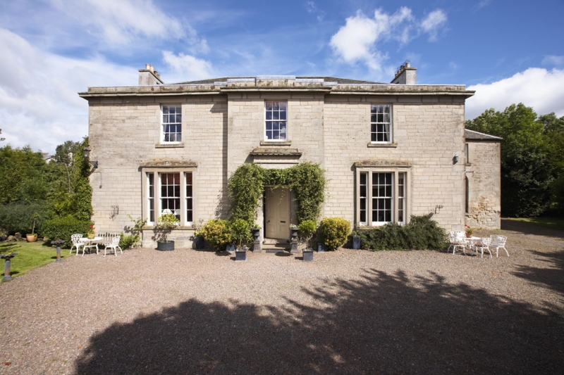
1847, possibly incorporating earlier structure (itself rebuilt 1757), with further improvements by James Stevenson, architect, 1874; later additions and alterations. 2-storey, 3-bay, classical former manse. Rectangular-plan (slightly advanced at centre) with lower, 2-storey, single bay wing recessed to right; single storey garage block adjoined at rear. Coursed and tooled cream sandstone to front; harl-pointed cream rubble sandstone to sides, rear and side wing; sandstone ashlar dressings. Raised base course; moulded eaves course beneath corniced eaves; parapet. Droved quoins; droved long and short surrounds to openings; sandstone mullions; projecting cills.
S (ENTRANCE) ELEVATION: steps to timber panelled door centred at ground; border-glazed fanlight; pilastered door-surround with plain frieze, dentilled cornice; single window aligned at 1st floor. Corniced tripartite windows with narrow side-lights at ground in bays recessed to left and right (block pediments); single windows aligned above. Lower wing recessed to outer right with blocked, round-arched window centred at ground; single window above.
W (SIDE) ELEVATION: 2-bay house with single windows at both floors in both bays (part infilled at 1st floor to right). Blind elevation to single storey garage block adjoined to left; coped rubble wall to outer left (remains of previous structure).
N (REAR) ELEVATION: main block with large, round-arched stair window at centre; 2 small windows at both floors in bay to right; gabled garage block projecting to outer right. Single windows at both floors in bay to left of centre (ground floor opening originally doorway); single windows at both floors in subsequent bay to left. Lower, piended block projecting to outer left with bipartite window centred at ground.
E (SIDE) ELEVATION: blind elevation to main block recessed to outer left. Lower, 2-bay wing projecting to right with single windows at both floors in both bays (blocked at ground to right).
4-, 8- and 12-pane glazing in timber sash and case windows; some modern glazing at rear; small rooflights. Grey slate piended roofs to main block and lower wing; grey slate pitched roof to garage. Coped and rendered wallhead stacks; circular cans. Cast-iron rainwater goods.
INTERIOR: not seen 1998.
Noted in the OS Name Book as "...a new built manse with 2 small fields and a vegetable garden attached." It is assumed that this 'new built' structure incorporated an older manse, which, according to both the Name Book and the STATISTICAL ACCOUNT was itself "...rebuilt in the year 1757." A report held in the SRO, dated February 1885, notes that the "manse was built 38 years ago [1847]." It also notes James Stevenson, Berwick-upon-Tweed, as architect of the 1874 alterations. Originally associated with the nearby Chirnside Parish Church (see separate list entry 'Chirnside, Kirkgate, Chirnside Parish Church'). No longer a manse, good details survived extensive fire damage in the 1990s. The 1862 Ordnance Survey map shows an L-plan range to the N, adjoining what is now the garage block, enclosing a courtyard at rear. Marked as 'Glebe House' on the 1996 OS map.
External links are from the relevant listing authority and, where applicable, Wikidata. Wikidata IDs may be related buildings as well as this specific building. If you want to add or update a link, you will need to do so by editing the Wikidata entry.


Other nearby listed buildings
