Latitude: 56.1078 / 56°6'28"N
Longitude: -3.7597 / 3°45'34"W
OS Eastings: 290658
OS Northings: 691958
OS Grid: NS906919
Mapcode National: GBR 1L.M1BW
Mapcode Global: WH5QF.6RX1
Plus Code: 9C8R465R+44
Entry Name: Clackmannan Tower.
Listing Date: 9 June 1960
Category: A
Source: Historic Scotland
Source ID: 332722
Historic Scotland Designation Reference: LB1946
Building Class: Cultural
ID on this website: 200332722
Location: Clackmannan
County: Clackmannanshire
Electoral Ward: Clackmannanshire East
Parish: Clackmannan
Traditional County: Clackmannanshire
Tagged with: Tower house
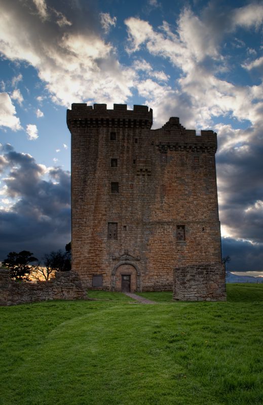
Large L-plan tower house. N. wing late 14th century at ground
1st and part of 2nd floor; S. wing and upper parts N. wing
15th century; alterations and additions 16th and 17th
centuries. Coursed rubble and ahslar, N. wing 4-storey and
cape house, S. wing 5-storey and capehouse. Corbelled
battlements. Entrance arched and pedimented 17th century.
Forecourt 16th/17th century, badly ruined.
Guardianship monument.
Scheduled Ancient Monument.
External links are from the relevant listing authority and, where applicable, Wikidata. Wikidata IDs may be related buildings as well as this specific building. If you want to add or update a link, you will need to do so by editing the Wikidata entry.


Other nearby listed buildings