Latitude: 57.6788 / 57°40'43"N
Longitude: -2.2603 / 2°15'37"W
OS Eastings: 384572
OS Northings: 865471
OS Grid: NJ845654
Mapcode National: GBR N8SF.76J
Mapcode Global: WH9N4.78X5
Plus Code: 9C9VMPHQ+GV
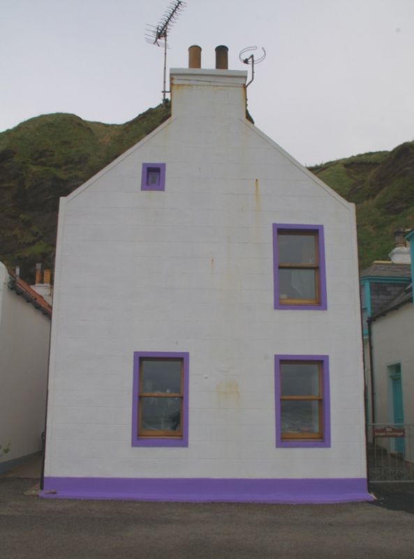
Entry Name: 28 Pennan
Listing Name: 28 Pennan
Listing Date: 16 April 1971
Category: B
Source: Historic Scotland
Source ID: 333684
Historic Scotland Designation Reference: LB2718
Building Class: Cultural
ID on this website: 200333684
Location: Aberdour (Aberdeenshire)
County: Aberdeenshire
Electoral Ward: Troup
Parish: Aberdour (Aberdeenshire)
Traditional County: Aberdeenshire
Tagged with: Building
Early 19th century with later heightening. 2-storey and
dormerless attic, 3-bay house with gable end to sea. Rendered
and lined as ashlar, harled rear. Centre entrance; right
ground floor window in extreme outer bay; 2 ground, 1 1st
floor and diminutive blocked attic window in seaward gable;
4- and 12-pane glazing. Coped end stacks; slate roof.
External links are from the relevant listing authority and, where applicable, Wikidata. Wikidata IDs may be related buildings as well as this specific building. If you want to add or update a link, you will need to do so by editing the Wikidata entry.


Other nearby listed buildings