Latitude: 55.0799 / 55°4'47"N
Longitude: -2.9502 / 2°57'0"W
OS Eastings: 339435
OS Northings: 576575
OS Grid: NY394765
Mapcode National: GBR 79VP.2S
Mapcode Global: WH7Z3.NLC0
Plus Code: 9C7V32HX+XW
Entry Name: Riverside Inn, Canonbie
Listing Name: Canonbie Village, Riverside Inn
Listing Date: 3 August 1971
Category: B
Source: Historic Scotland
Source ID: 334557
Historic Scotland Designation Reference: LB3499
Building Class: Cultural
Also known as: Canonbie, Riverside Inn
ID on this website: 200334557
Location: Canonbie
County: Dumfries and Galloway
Electoral Ward: Annandale East and Eskdale
Parish: Canonbie
Traditional County: Dumfriesshire
Tagged with: Architectural structure
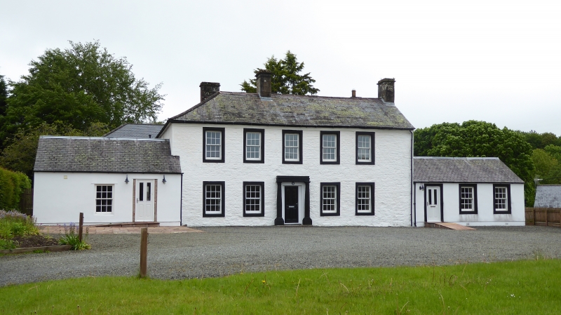
Appearance suggests early 19th century, but several building
phases, earliest perhaps in first half 18th century; rear wing
extended mid 19th century. L-plan, essentially 2 narrow ranges
in double-pile with twin-gabled E elevation, roof piended at W
and continued over rear wing. 2 storeys, with altered/added low
flanking wings. Rubble-built (rear wing, at least, built of river
bank pebbles) with ashlar/rubble dressings; all whitewashed
with painted ashlar margins.
S ELEVATION: earliest surviving work probably in 3-bay part
nearest E; latter raised at least once, 2 bays added left to
form symmetrical 5-bay front with central painted and
badly-weathered doric-columned doorpiece (glazed modern door);
sash windows throughout in chamfered margins and with 12-pane
glazing pattern. Corniced stacks over original end walls.
Slate roofs. N elevation altered with some brick-margined
openings; door formerly at ground and at 1st floor - original
loft - level in re-entrant angle.
Cottage at N not included in listing.
Formerly known as "Forge"; on site of an 18th century forge,
and presumably incorporates some associated buildings.
New Statistical Account notices (1836) Forge as the occasional
residence of Pultney Main.
Some slag incorporated in garden rockery.
1718 plan in SRO (RHP 9452/42) gives sketch elevation of
2 buildings at "Forge" and GD 224/406/9/11 refers to lease
of "the Forge" in 1712.
External links are from the relevant listing authority and, where applicable, Wikidata. Wikidata IDs may be related buildings as well as this specific building. If you want to add or update a link, you will need to do so by editing the Wikidata entry.


Other nearby listed buildings