Approximate Location Map
Large Map »
Latitude: 55.0978 / 55°5'52"N
Longitude: -2.9696 / 2°58'10"W
OS Eastings: 338224
OS Northings: 578581
OS Grid: NY382785
Mapcode National: GBR 79PH.WD
Mapcode Global: WH7Z3.C449
Plus Code: 9C7V32XJ+45
Entry Name: Gilnockie Tower
Listing Name: Hollows or Gilnockie Tower
Listing Date: 3 August 1971
Category: A
Source: Historic Scotland
Source ID: 334586
Historic Scotland Designation Reference: LB3527
Building Class: Cultural
Also known as: Gilnockie Castle
Hollows Tower
Holehouse Tower
Armstrong's Tower
Gillknocky Tower
Gilnocky Tower
ID on this website: 200334586
Location: Canonbie
County: Dumfries and Galloway
Electoral Ward: Annandale East and Eskdale
Parish: Canonbie
Traditional County: Dumfriesshire
Tagged with: Castle Tower house
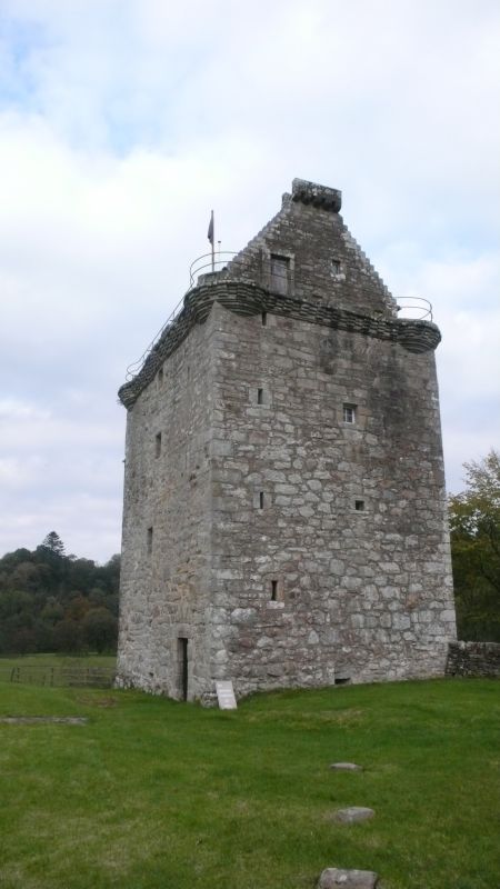
16th century tower house shell sympathetically restored for
domestic use 1979-80, W G Dawson architect. Roughly coursed
rubble, ashlar dressings, rectangular or slit openings, mostly roll-moulded, some with relieving arches. Door at S end of W
wall; central gun port to elevations at ground level;
small-paned windows; splayed base course; continuous corbel
table with cable moulding curved over angles, rope-moulding
raised at intervals (some upper stonework removed).
Crow-stepped gables, corbelled apex beacon platform at S,
corniced end stack at N. Slate roof.
INTERIOR: lower level vaulted (prehistoric stone in floor at
door to latter); circular stair within SW angle.
The beacon platform is a rarity. Usually known as Hollows
Tower, sometimes as Gilnockie Tower, though local tradition
claims that the latter stood on the E bank of the Esk opposite.
Upgraded B to A 12.7.88.
External links are from the relevant listing authority and, where applicable, Wikidata. Wikidata IDs may be related buildings as well as this specific building. If you want to add or update a link, you will need to do so by editing the Wikidata entry.


Other nearby listed buildings
