Approximate Location Map
Large Map »
Latitude: 55.044 / 55°2'38"N
Longitude: -3.3222 / 3°19'20"W
OS Eastings: 315609
OS Northings: 572966
OS Grid: NY156729
Mapcode National: GBR 5B73.JN
Mapcode Global: WH6XZ.YH51
Plus Code: 9C7R2MVH+J4
Entry Name: Hoddom Castle
Listing Name: Hoddom Castle with Fosse Bridge and Driveway Bridge to South
Listing Date: 3 August 1971
Category: A
Source: Historic Scotland
Source ID: 334634
Historic Scotland Designation Reference: LB3558
Building Class: Cultural
ID on this website: 200334634
Location: Cummertrees
County: Dumfries and Galloway
Electoral Ward: Annandale South
Parish: Cummertrees
Traditional County: Dumfriesshire
Tagged with: Castle
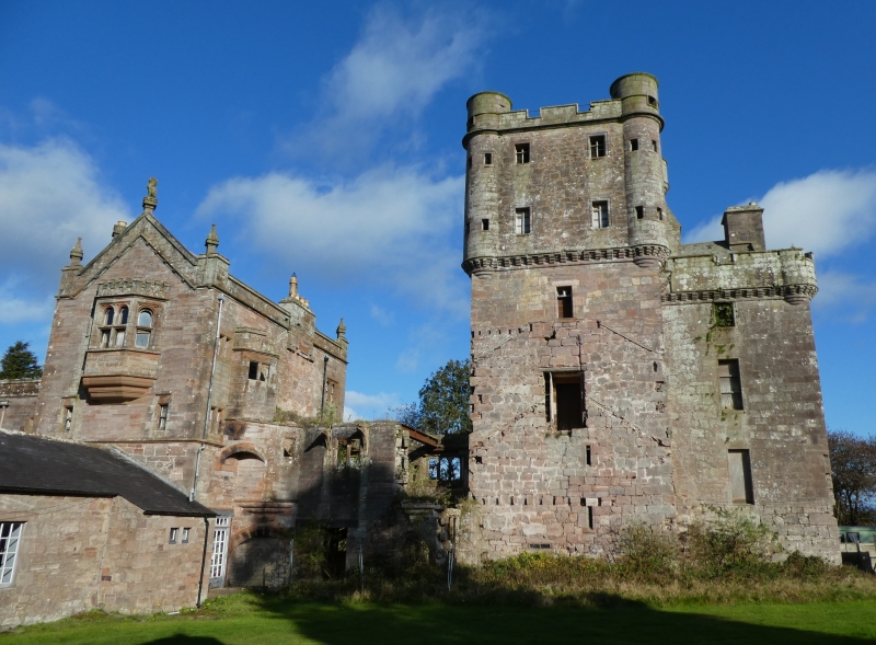
Large asymmetrical mansion, nucleus a fine L-plan 16th
century tower house, main (S) courtyard W walls, gateway and
turrets largely 17th century; circa 1826 additions by William
Burn to S and to W of tower largely demolished circa 1970;
extensive neo-Jacobean 1, 2 and 3-storey additions to N and
to W built 1878-1891 (dated throughout), some, at least, by
Wardrop and Anderson circa 1886; additions mainly comprising
open stable court, service ranges to N beyond: now run as a
holiday centre for caravan park; tower is abandoned. Small
driveway bridge to S (above fosse bridge) possibly 17th/18th
century.
TOWER: various alterations particularly at upper level and
to interior; fantastic skyline probably 18th century. 4
storeys with attic and corbelled parapets, jamb corbelled 2
storeys higher with conical roofed bartizans and 19th century
cap-house; parapet encloses slated and crow-stepped-gabled
main roof. Massively thick red ashlar walls, openings mostly roll-moulded: deep raggles and door slappings where later
ranges abutted. Rope-moulded doorway in re-entrant angle;
wide horizontal gunports at ground; some upper floor windows
enlarged.
INTERIOR: vaulted ground floor; spacious turnpike within
jamb (narrower at upper floors); central partition wall at
each level; some mural chambers.
MAIN COURTYARD: (to S and W of tower) W wall with 2-storey
drum turret at either end, that to N 17th century (upper part
rebuilt circa 1975) and vaulted at ground; roll-moulded wide segmental-arched gateway with ball finials and bellcote all
probably 17th century; gateway to S and castellated
Tudor-arched fosse bridge all probably by Burn. All rubble
and ashlar.
19TH CENTURY ADDITIONS: mostly stugged red ashlar with
polished dressings; some mullioned windows; corbelled
parapets, raised over gables. Tall gabled bay to N of tower
(with shaped and finialled skews) probably by Burn;
corresponding (1889) bay to N linked by (1889) stable (now a
bar) with cast-iron columned shelter to court: latter walled
at W, 2-storey blocks flanking gate, with dummy
machicolations, also by Burn. Service ranges to N mostly
single storey, in similar style and dated 1891.
DRIVEWAY BRIDGE: short segmental arch over stream; all
rubble-built; widened, probably circa 1826.
Category A for quality of tower.
Additions by Burn for General Sharpe of Hoddom; later work
for Brook of Huddersfield who purchased Hoddom in 1877.
Requisitioned by the military, and since unoccupied.
External links are from the relevant listing authority and, where applicable, Wikidata. Wikidata IDs may be related buildings as well as this specific building. If you want to add or update a link, you will need to do so by editing the Wikidata entry.


Other nearby listed buildings
