History in Structure

Corra Castle

A Category A Listed Building in Lesmahagow, South Lanarkshire

More Photos »
Approximate Location Map
Large Map »

Coordinates

Latitude: 55.6533 / 55°39'11"N

Longitude: -3.7779 / 3°46'40"W

OS Eastings: 288229

OS Northings: 641410

OS Grid: NS882414

Mapcode National: GBR 2312.X8

Mapcode Global: WH5SQ.Y56F

Plus Code: 9C7RM63C+8V

Entry Name: Corra Castle

Listing Date: 12 January 1971

Category: A

Source: Historic Scotland

Source ID: 339644

Historic Scotland Designation Reference: LB7680

Building Class: Cultural

ID on this website: 200339644
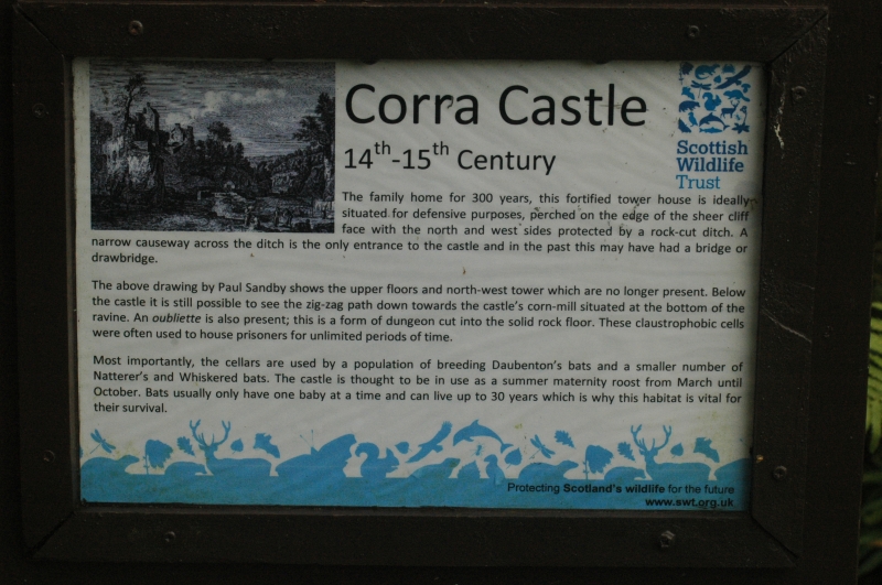
Location: Lesmahagow

County: South Lanarkshire

Electoral Ward: Clydesdale North

Parish: Lesmahagow

Traditional County: Lanarkshire

Tagged with: Castle Building

Find accommodation in
Lanark

Description

Ruin.

Statement of Interest

Scheduled Monument.

External Links

External links are from the relevant listing authority and, where applicable, Wikidata. Wikidata IDs may be related buildings as well as this specific building. If you want to add or update a link, you will need to do so by editing the Wikidata entry.

Recommended Books

Other nearby listed buildings

BritishListedBuildings.co.uk is an independent online resource and is not associated with any government department. All government data published here is used under licence. Please do not contact BritishListedBuildings.co.uk for any queries related to any individual listed building, planning permission related to listed buildings or the listing process itself.

British Listed Buildings is a Good Stuff website.