Approximate Location Map
Large Map »
Latitude: 57.5978 / 57°35'52"N
Longitude: -3.4247 / 3°25'29"W
OS Eastings: 314942
OS Northings: 857318
OS Grid: NJ149573
Mapcode National: GBR K8XM.V7Q
Mapcode Global: WH6JK.C9D8
Plus Code: 9C9RHHXG+44
Entry Name: Church Of Scotland, Pluscarden
Listing Name: Pluscarden Church (Church of Scotland)
Listing Date: 9 November 1987
Category: B
Source: Historic Scotland
Source ID: 340585
Historic Scotland Designation Reference: LB8443
Building Class: Cultural
Also known as: Pluscarden Kirk
Pluscarden, Church Of Scotland
ID on this website: 200340585
Location: Elgin
County: Moray
Electoral Ward: Heldon and Laich
Parish: Elgin
Traditional County: Morayshire
Tagged with: Church building
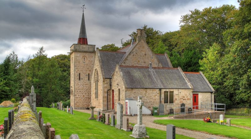
A and W Reid and Wittet, 1898. Gothic, cruciform plan church; coursed rubble, ashlar dressings. Square tower at SW corner rising slightly above roof height with plain corbelled parapet and angle spout gargoyles, capped with octagonal fleche and weather-cock. Recessed and hoodmoulded round headed entrance in base of tower, which has triple lancets to W elevation and 2 single lancets to each elevation at 1st
stage. Large 3-light curvilinear traceried and hoodmoulded window in W gable; similar treatment to 2-light windows in N and S transept gables.
Simple buttresses; slate roof; tiled ridge cresting. Simple rectangular rubble parish room at N gable end. Slate roof.
INTERIOR: original pine interior; modern stained glass to small E gable wheel window.
Ecclesiastical building in use as such. Formerly Free Church, building cost of about $1,500. The congregation had worshipped until 1898, in part of the Abbey, as had the Church of Scotland before them (all but
one family in the parish "came out" in 1843). The congregation were obliged to build a church when the Abbey was purchased by the Marquis of Bute (who gave them the site, known as the Drinking Hill). Present fleche erected in 1960.
External links are from the relevant listing authority and, where applicable, Wikidata. Wikidata IDs may be related buildings as well as this specific building. If you want to add or update a link, you will need to do so by editing the Wikidata entry.


Other nearby listed buildings
